- Gratis verzending vanaf 30 euro
- Levert in Nederland, België etc.
- Meer dan 30.000 titels
- Vakkundige klantenservice
- Snelle levering
- Veilig en eenvoudig betalen

Direct contact?
Bel +31 (0)6 42428571
maandag t/m vrijdag
van 10 tot 17 uur
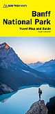
Wandelkaart 5 Banff & Mount Assiniboine | Gem Trek Publishing
Water- en scheurvaste wandelkaart

Hiking map of a portion of Banff National Park (Alberta and British Columbia), centered on Mount Assiniboine. Waterproof map published by Gem Trek. Contour lines at 50-metre intervals (150 feet), hiking trails with detailed explanations, campsites, hotels, outdoor activities and detailed legend are included. This map covers the most popular hiking and mountain biking terrain in Banff National Park, from Lake Louise in the north to the south end of Banff National Park, plus all of Mt. Assiniboine Provincial Park.
All of the day hikes in and around Banff townsite are covered on this map, such as Tunnel Mountain, Sundance Canyon, Bow Falls to the Hoodoos, Johnston Canyon, Castle Mountain Lookout and the network of trails at Sunshine Village. As well, the popular, multi-day hiking and equestrian loops to Egypt Lake, Shadow Lake and the Sawback Trail up through Mystic Pass are shown in their entirety. On the back of the map are 1:50 000-scale inset maps of the Mt. Assiniboine and Sunshine Village areas. Also on the back are trail descriptions and photos of 19 recommended day hikes, four classic multi-day trips and six mountain bike rides. Each of these described trails is referenced and color-coded to the map on the front.
Schaal: 1:100.000
Engelstalig
EAN: 9781895526981
Uitgeverij: Gem Trek Publishing (Canada)
Serie: Gem Trek Wandelkaart
Meest recente editie
Engelstalig


Op voorraad
Levertijd 1 week (Nederland) (wegens vakantie)
- Vakkundige klantenservice
- Groot assortiment
- Gratis retourneren binnen 14 dagen
- Aangesloten bij WebwinkelKEUR
€ 16,99
Verder in deze serie

- Wandelkaart 1 Jasper National Park & Maligne Lake | Gem Trek Publishing
- Wandelkaart 2 Columbia Icefield Guide & Map | Gem Trek Publishing
- Wandelkaart 3 Bow Lake & Saskatchewan Crossing | Gem Trek Publishing
- Wandelkaart 4 Lake Louise & Yoho | Gem Trek Publishing
- Wandelkaart 6 Canmore & Kananaskis Village | Gem Trek Publishing
- Wandelkaart 7 Kananaskis Lakes (Peter Lougheed Provincial Park) | Gem Trek Publishing
- Wandelkaart 8 Bragg Creek & Sheep Valley | Gem Trek Publishing
- Wandelkaart 8 Bragg Creek & Sheep Valley | Gem Trek Publishing
- Wandelkaart 9 Highwood & Cataract Creek | Gem Trek Publishing
- Wandelkaart 10 Kootenay National Park | Gem Trek Publishing
- Wandelkaart 10 Kootenay National Park | Gem Trek Publishing
- Wandelkaart 11 Banff Up-Close | Gem Trek Publishing
- Wandelkaart 12 Best of Jasper | Gem Trek Publishing
- Wandelkaart 13 Best of Lake Louise | Gem Trek Publishing
- Wandelkaart 14 Lake O'hara | Gem Trek Publishing
- Wandelkaart 16 Waterton Lakes National Park | Gem Trek Publishing
- Wandelkaart 17 Banff: Egypt Lake | Gem Trek Map
- Wandelkaart Jasper National Park Map and Guide | Gem Trek Publishing
- Wegenkaart Best of Icefield Parkway | Gem Trek Publishing
Meer producten die interessant kunnen zijn
Wegenkaart - Landkaart 1 Banff National Park Map and Guide | Gem Trek Publishing
Water- en scheurvaste wandelkaart
€ 15,99
Wandelkaart 1 Jasper National Park & Maligne Lake | Gem Trek Publishing
Water- en scheurvaste wandelkaart
€ 17,50