- Gratis verzending vanaf 30 euro
- Levert in Nederland, België etc.
- Meer dan 30.000 titels
- Vakkundige klantenservice
- Snelle levering
- Veilig en eenvoudig betalen

Direct contact?
Bel +31 (0)6 42428571
maandag t/m vrijdag
van 10 tot 17 uur
Wandelkaart Ben Nevis and Glen Coe - Mountain Map | Harvey Maps
Water- en scheurvaste wandelkaart

De Harvey Map is de wandelkaart voor het wandelen in de mooiste natuurgebieden in het Groot-Brittannië. Duidelijke topografische wandelkaarten met praktische informatie van de route zoals overnachtingsmogelijkheden, eetgelegenheden en bezienswaardigheden. Deze wandelkaart is scheur- en watervast. Met GPS compatible (UTM-Grid). Stunning new map of Ben Nevis and Glen Coe. "This excellent Ben Nevis and Glen Coe map provides all the details needed for safe navigation on these iconic mountains". Cameron McNeish . Printed on polyethylene - durable, tear-resistant and 100% waterproof. Made in cooperation with the British Mountaineering Council and the Mountaineering Council of Scotland. Scale 1:40,000, the Magic Scale. Colour shading for easy identification of hills and valleys, detailed crag information for climbers.. Less than half the weight of a laminated map. Section on navigation on Ben Nevis and detailed 1:15,000 enlargement of the summit with bad visibility descent route. Geological map of Ben Nevis and Glen Coe specially designed by the British Geological Survey. Mountain incident and first aid advice, yips on using your map and compass and useful local phone numbers and websites
Schaal: 1:40.000
Engelstalig


Op voorraad
Levertijd 3 dagen (Nederland)
- Vakkundige klantenservice
- Groot assortiment
- Gratis retourneren binnen 14 dagen
- Aangesloten bij WebwinkelKEUR
€ 28,99
Meer producten die interessant kunnen zijn
Topografische kaarten Centraal-Schotland / Ben Nevis
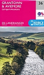
Topografische Wandelkaart 36 Grantown / Aviemore Cairngorm Mountains - Landranger Map
Wandelkaart & Fietskaart | Ordnance Survey (OS) Groot-Brittannië
€ 18,99
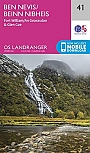
Topografische Wandelkaart 41 Ben Nevis / Fort William / Glen Coe - Landranger Map
Wandelkaart & Fietskaart | Ordnance Survey (OS) Groot-Brittannië
€ 18,99
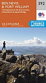
Topografische Wandelkaart 392 Ben Nevis / Fort William The Mamores & The Grey Corries Kinlochleven & Spean Bridge - Explorer Map
Wandelkaart & Fietskaart | Ordnance Survey (OS) Groot-Brittannië
€ 18,99
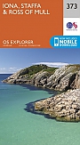
Topografische Wandelkaart 373 Iona / Staffa / Ross of Mull - Explorer Map
Wandelkaart & Fietskaart | Ordnance Survey (OS) Groot-Brittannië
€ 18,99
Wandelgidsen Centraal-Schotland / Ben Nevis