- Gratis verzending vanaf 30 euro
- Levert in Nederland, België etc.
- Meer dan 30.000 titels
- Vakkundige klantenservice
- Snelle levering
- Veilig en eenvoudig betalen

Direct contact?
Bel +31 (0)6 42428571
maandag t/m vrijdag
van 10 tot 17 uur
Topografische Wandelkaart OL24 van Groot-Brittannië (1:25.000) Peak District - White Peak area - Explorer Map OL 24
Wandelkaart | Ordnance Survey (OS) Groot-Brittannië
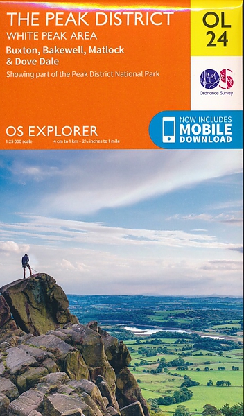
Deze gedetailleerde en informatieve topografische kaart (stafkaart, schaal 1:25.000) van Groot-Brittannië bevat alle topografische elementen van het landschap en geeft daarmee een nauwkeurig beeld van het terrein. Daarnaast heeft Ordnance Survey (OS) ook toeristische informatie op de meeste kaart verwerkt, zoals de aanduiding voor campings en ingetekende wandelpaden . Deze kaart is ideaal voor wandelaars of fietsers, maar ook voor de scouting of sportverenigingen die activiteiten in Groot-Brittannië gaan uitvoeren. De kaarten zijn voorzien van een GPS aanduiding en een duidelijke legenda. Whether you"re a seasoned outdoor expert or a leisurely sightseer, with the OS Explorer OL24 map of the White Peaks to hand, you"ll be on the right track no matter where your adventure takes you. Trusted by outdoor enthusiasts from all walks of life, this easy-to-follow fold-up map is the perfect companion for all your excursions in the White Peaks area of the Peak District, from days out, to week-long hikes. Taking its name from its limestone landscape, this part of the Peaks is full of fascinating caves and dry river valleys to explore. If walking"s what you"ve set out to do, why not tackle the 25-mile long White Peaks Challenge? Using the pretty town of Stoney Middleton as a base, serious climbers can take on "Our Father", a challenging climb up Windy Buttress. Alternatively, head underground to explore over 3 000 metres of caves at the limestone gorge of Middleton Dale. There are bustling towns in the white peak area of the Peak District including Buxton and Matlock, or you could treat yourself to one of Bakewell's legendary tarts. Whether you"re passionate about cycling and sightseeing, or rambling and riding, you"ll get the most out of your days out in the White Peaks with the OS Explorer OL24 map to guide you. You"ll find every fine detail covered, from rivers to rights of way, as well as a wealth of information you won"t find on other maps. Highlights include: Castle rock, Middleton Dale, Derbyshire Dales, The Roaches, Buxton, Bakewell, Matlock, Dovedale, Chatsworth House, limestone caves, and the thermal springs at Middleton Stoney.
Schaal: 1:25.000
EAN: 9780319263846
Uitgeverij: Ordnance Survey (UK)
Serie: Explorer Map Midden-Engeland
Meest recente editie


Op voorraad
Overmorgen in huis (Nederland)
- Vakkundige klantenservice
- Groot assortiment
- Gratis retourneren binnen 14 dagen
- Aangesloten bij WebwinkelKEUR
€ 18,99
Verder in deze serie
- Topografische Wandelkaart 190 Malvern Hills / Bredon Hill Tewkesbury, Ledbury, Pershore & Upton upon Severn - Explorer Map
- Topografische Wandelkaart 191 Banbury / Bicester / Chipping Norton Brackley - Explorer Map
- Topografische Wandelkaart 192 Buckingham / Milton Keynes Leighton Buzzard & Woburn - Explorer Map
- Topografische Wandelkaart 193 Luton / Stevenage Hitchin & Ampthill - Explorer Map
- Topografische Wandelkaart 194 Hertford / Bishop's Stortford Buntingford & Clavering - Explorer Map
- Topografische Wandelkaart 204 Worcester / Droitwich Spa - Explorer Map
- Topografische Wandelkaart 205 Stratford-upon-Avon / Evesham Alcester - Explorer Map
- Topografische Wandelkaart 206 Edge Hill / Fenny Compton Badby, Kineton & Middle Tysoe - Explorer Map
- Topografische Wandelkaart 207 Newport Pagnell / Northampton South Towcester & Olney - Explorer Map
- Topografische Wandelkaart 208 Bedford / St Neots Sandy & Biggleswade - Explorer Map
- Topografische Wandelkaart 209 Cambridge Royston, Duxford & Linton - Explorer Map
- Topografische Wandelkaart 218 Kidderminster / Wyre Forest Bridgnorth - Explorer Map
- Topografische Wandelkaart 219 Wolverhampton / Dudley Stourbridge & Kidderminster - Explorer Map
- Topografische Wandelkaart 220 Birmingham Walsall, Solihull & Redditch - Explorer Map
- Topografische Wandelkaart 221 Coventry / Warwick Royal Leamington Spa & Kenilworth - Explorer Map
- Topografische Wandelkaart 222 Rugby / Daventry Southam & Lutterworth - Explorer Map
- Topografische Wandelkaart 223 Northampton / Market Harborough Brixworth & Pitsford Water - Explorer Map
- Topografische Wandelkaart 224 Corby/ Kettering / Wellingborough Rockingham Forest - Explorer Map
- Topografische Wandelkaart 225 Huntingdon / St Ives Grafham Water - Explorer Map
- Topografische Wandelkaart 227 Peterborough /March / Whittlesey / Chatteris /Oundle March, Whittlesey, Chatteris - Explorer Map
- Topografische Wandelkaart 232 Nuneaton / Tamworth Lichfield & Atherstone - Explorer Map
- Topografische Wandelkaart 233 Leicester / Hinckley - Explorer Map
- Topografische Wandelkaart 234 Rutland Water / Stamford / Oakham - Explorer Map
- Topografische Wandelkaart 235 Wisbech / Peterborough North / Market Deeping & Crowland - Explorer Map
- Topografische Wandelkaart 242 Telford / Ironbridge / the Wrekin - Explorer Map
- Topografische Wandelkaart 243 Market Drayton Loggerheads & Eccleshall - Explorer Map
- Topografische Wandelkaart 244 Cannock Chase / Chasewater Stafford, Rugeley & Cannock - Explorer Map
- Topografische Wandelkaart 245 The National Forest Burton upon Trent, Swadlincote, Ashby-de-la-Zouch & Coalville - Explorer Map
- Topografische Wandelkaart 246 Loughborough Melton Mowbray & Syston - Explorer Map
- Topografische Wandelkaart 247 Grantham Bottesford & Colsterworth - Explorer Map
- Topografische Wandelkaart 248 Bourne / Heckington Billingborough & Morton - Explorer Map
- Topografische Wandelkaart 249 Spalding / Holbeach Long Sutton & Kirton - Explorer Map
- Topografische Wandelkaart 258 Stoke-on-Trent / Newcastle-under-Lyme Biddulph & Stone - Explorer Map
- Topografische Wandelkaart 259 Derby / Utoxeter Uttoxeter, Ashbourne & Cheadle - Explorer Map
- Topografische Wandelkaart 260 Nottingham / Vale of Belvoir - Explorer Map
- Topografische Wandelkaart 261Boston Tattershall, Billinghay & Heckington - Explorer Map
- Topografische Wandelkaart 268 Wilmslow / Macclesfield / Congleton Altrincham, Knutsford & Sandbach - Explorer Map
- Topografische Wandelkaart 269 Chesterfield / Alfreton Sutton in Ashfield & Bolsover - Explorer Map
- Topografische Wandelkaart 270 Sherwood Forest Mansfield, Worksop & Edwinstowe - Explorer Map
- Topografische Wandelkaart 271 Newark-on-Trent Retford, Southwell & Saxilby - Explorer Map
- Topografische Wandelkaart 272 Lincoln Sleaford, Metheringham & Navenby - Explorer Map
- Topografische Wandelkaart 273 Lincolnshire Wolds South Horncastle & Woodhall Spa - Explorer Map
- Topografische Wandelkaart 274 Skegness / Alford / Spilsby Chapel St Leonards & Wainfleet All Saints - Explorer Map
- Topografische Wandelkaart OL1 van Groot-Brittannië (1:25.000) Peak District - Dark Peak area - Explorer Map OL 1
Meer producten die interessant kunnen zijn
Wandelgidsen Midden-Engeland


Wandelgids 74 Malverns to Warwickshire Pathfinder Guide
Pathfinder Guide 01 | Met Ordanance Survey kaarten
€ 17,95
Tijdelijk niet leverbaar

Reisgidsen Midden-Engeland


Reisgids Slow Norfolk Bradt Travel Guide
Local, Characterful Guides To Britain's Special Places
€ 21,50
Wegenkaarten Midden-Engeland

Fietskaarten Midden-Engeland