- Gratis verzending vanaf 30 euro
- Levert in Nederland, België etc.
- Meer dan 30.000 titels
- Vakkundige klantenservice
- Snelle levering
- Veilig en eenvoudig betalen

Direct contact?
Bel +31 (0)6 42428571
maandag t/m vrijdag
van 10 tot 17 uur
Wandelgids The Severn Way the UK's longest river from source to sea | Cicerone
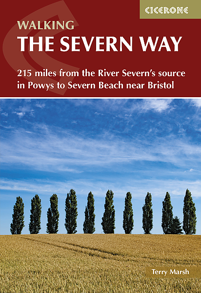
The Severn Way is a 215 mile (348km) walk through the Welsh borders. Beginning at the River Severn's source in Powys, mid-Wales, this guidebook gives all the information needed to enjoy walking the route. The Severn Way meanders through superb landscapes, interesting towns and villages before finishing near Bristol, in south-west England. May to September should avoid both the usual periods of flooding and the glutinous aftermath they bring. Main centres are Worcester and Gloucester; marginally lesser centres are Newtown, Welshpool, Shrewsbury, Bridgnorth, Stourport and Tewkesbury, plus numerous small villages and hamlets. Any regular walker would find no difficulty following the Severn Way; once descended from the Hafren Forest and the upper Severn, then easy riparian loveliness ensues all the way to Severn Beach. Equipment and clothing for day walking is adequate, plus extra in the way of liquid and food.
Engelstalig
EAN: 9781786311405
Uitgeverij: Cicerone Press
Verschijningsdatum: 2023
Meest recente editie
Engelstalig
176 pagina's


Op voorraad
Overmorgen in huis (Nederland)
- Vakkundige klantenservice
- Groot assortiment
- Gratis retourneren binnen 14 dagen
- Aangesloten bij WebwinkelKEUR
€ 21,99
Meer producten die interessant kunnen zijn
Topografische kaarten Midden-Engeland

Topografische Wandelkaart 196 Sudbury / Hadleigh / Dedham Vale Lavenham & Long Melford - Explorer Map
Wandelkaart & Fietskaart | Ordnance Survey (OS) Groot-Brittannië
€ 18,99

Topografische Wandelkaart 205 Stratford-upon-Avon / Evesham Alcester - Explorer Map
Wandelkaart & Fietskaart | Ordnance Survey (OS) Groot-Brittannië
€ 18,99

Topografische Wandelkaart 211 Bury St Edmunds / Stowmarket Debenham & Elmswell - Explorer Map
Wandelkaart & Fietskaart | Ordnance Survey (OS) Groot-Brittannië
€ 18,99
Tijdelijk niet leverbaar
Topografische Wandelkaart 212 Woodbridge / Saxmundham Aldeburgh & Framlingham - Explorer Map
Wandelkaart & Fietskaart | Ordnance Survey (OS) Groot-Brittannië
€ 18,99
Reisgidsen Midden-Engeland


Reisgids Slow Norfolk Bradt Travel Guide
Local, Characterful Guides To Britain's Special Places
€ 21,50
Wegenkaarten Midden-Engeland

Fietskaarten Midden-Engeland