- Gratis verzending vanaf 30 euro
- Levert in Nederland, België etc.
- Meer dan 30.000 titels
- Vakkundige klantenservice
- Snelle levering
- Veilig en eenvoudig betalen

Direct contact?
Bel +31 (0)6 42428571
maandag t/m vrijdag
van 10 tot 17 uur
Wandelgids Shorter Treks in the Pyrenees | Cicerone Guidebooks

A guidebook to seven circular treks exploring the Pyrenees of France and Spain. Seven 1 or 2 week routes in dramatic mountain scenery, including the Pic du Midi d'Ossau, Vignemale, Ordesa Canyon, Gavernie, Puigmal and Canigou. Using mostly waymarked mountain paths, with some boulderfield or easy scrambling, the treks are designed with accommodation in mountain refuges or mountain villages at the end of each stage, though there are plenty of options to camp for those who prefer to backpack.
Detailed descriptions for each stage of the route are accompanied by sketch maps and elevation profiles, and there are notes on planning, equipment and access.
The Pyrenees stretch 400km from Atlantic to Mediterranean, forming a barrier rising to over 3000m between France and Spain. The steep rolling hills of the Basque Country give way to the spectacular alpine peaks and passes of the High Pyrenees and the gentler mountains of eastern Catalonia. With variants and options for shortening the route, or adding the ascent of nearby peaks, the treks featured in the guidebook are a perfect base for discovering this magnificient and varied mountain range.
Engelstalig
EAN: 9781852849306
Uitgeverij: Cicerone Press
Verschijningsdatum: 2019
Meest recente editie
Engelstalig

Op voorraad
Levertijd 3 dagen (Nederland)
- Vakkundige klantenservice
- Groot assortiment
- Gratis retourneren binnen 14 dagen
- Aangesloten bij WebwinkelKEUR
€ 21,99
Meer producten die interessant kunnen zijn
Wandelkaarten Pyreneeën
Topografische kaarten Pyreneeën
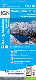
Topografische Wandelkaart van Frankrijk 2249OT - Bourg Madame / Col Puymorens Pic Carlit Port d'Envalira
Carte de Randonnee | Wandelkaart | Institut Geographique National (IGN) Frankrijk
€ 16,90

Topografische Wandelkaart van Frankrijk 1345OT - Cambo-les-Bains / Hasparren
Carte de Randonnee | Wandelkaart | Institut Geographique National (IGN) Frankrijk
€ 16,90

Topografische Wandelkaart van Frankrijk 1245OT - Hendaye / St-Jean-de-Luz / Cote d'Argent
Carte de Randonnee | Wandelkaart | Institut Geographique National (IGN) Frankrijk
€ 16,90
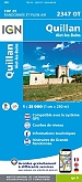
Topografische Wandelkaart van Frankrijk 2347OT - Quillan / Alet-Les-Bains
Carte de Randonnee | Wandelkaart | Institut Geographique National (IGN) Frankrijk
€ 16,90
Wegenkaarten Pyreneeën

Wegenkaart - Landkaart Pyreneeën Pyrenäen - World Mapping Project (Reise Know-How)
Water- en scheurvaste wegenkaart
€ 13,50
Pelgrimeren naar Santiago de Compostella Pyreneeën
Wandelgids 6533 Pyreneeën GR653 Saint Jacques De Compostelle Via Arles Toulouse 6533 | FFRP Topoguides
GR 653 | Ref. 6533 | FFRP Topoguides
€ 19,99
Wandelgids Camino de Santiago - Via Podiensis GR65 | Cicerone Press
Le Puy to the Pyrenees on the GR 65
€ 22,99
Reisgidsen Pyreneeën
Fietskaarten Pyreneeën

Wegenkaart - Fietskaart D64 Top Pyrenees Atlantiques | IGN Top Tourisme
Pau - Bayonne - Bearn - Pays Basque - Biarritz
€ 10,90
Fietskaart 166 Dax Bayonne Pays Basque - IGN Top 100 - Tourisme et Velo
Water- en scheurvaste fietskaart
€ 10,50
Fietsgidsen Pyreneeën

Fietsgids Canal du Midi Bikeline Esterbauer
Entlang des Weltkulturerbes von Toulouse ans Mittelmeer - Mit Canal de la Robine - 322 km
€ 14,99
