- Gratis verzending vanaf 30 euro
- Levert in Nederland, België etc.
- Meer dan 30.000 titels
- Vakkundige klantenservice
- Snelle levering
- Veilig en eenvoudig betalen

Direct contact?
Bel +31 (0)6 42428571
maandag t/m vrijdag
van 10 tot 17 uur
Wandelgids Walking The Skye Trail | Cicerone Guidebook
A challenging backpacking route from Rubha Hunish to Broadford

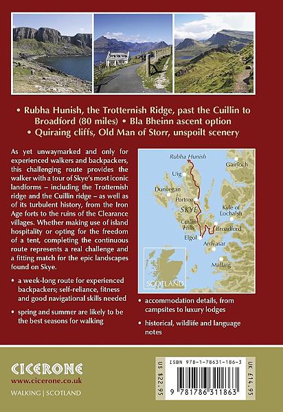
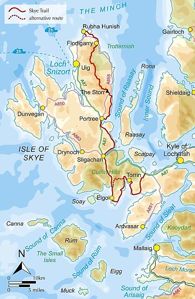
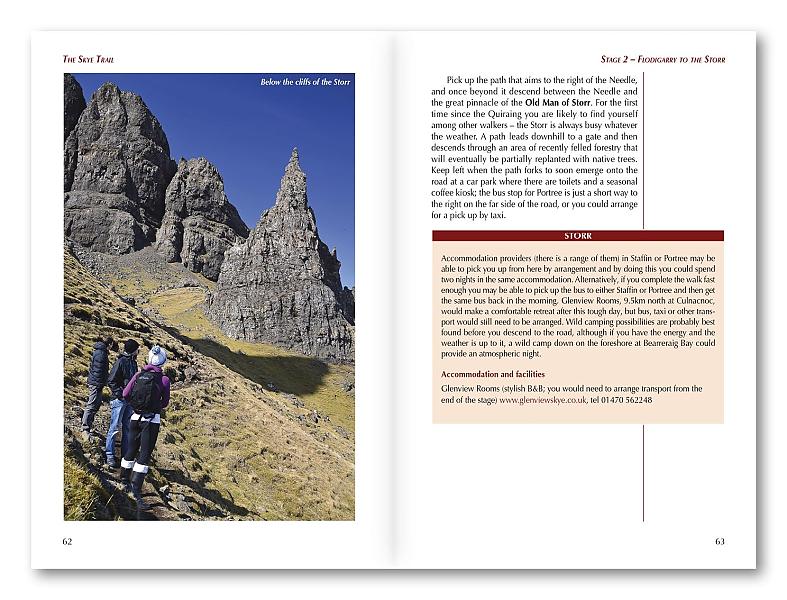
This guidebook describes the challenging 80-mile (128km) Skye Trail, a week-long trek across the magical Isle of Skye, the largest island in Scotland's Inner Hebrides. As yet unwaymarked, the route demands navigational skill, fitness and self-reliance and is therefore suitable for experienced backpackers and mountain walkers. The trail is presented in 7 stages of between 7 ¼ (11.5km) and 17 ¾ miles (28.5km), plus an alternative stage to include an ascent of Bla Bheinn. Alongside detailed route description, 1:50,000 OS mapping and stunning photography, the guide provides a wealth of information about Skye"s rich history, culture, literature, geology, wildlife and plants, as well as practical advice such as when to go, what to take and where to stay. Blending information with inspiration, the result is an ideal companion to trekking this magnificent route. From the headland of Rubha Hunish, through Portree to Broadford, the Skye Trail provides the walker with a tour of Skye's most iconic landforms - including the Quiraing, the Old Man of Storr and the Cuillin - as well as of its turbulent history, from Iron Age forts to the ruins of Clearance villages. Whether making use of island hospitality or opting for the freedom of a tent, completing the continuous route represents a real challenge and a fitting match for the epic landscapes found on Skye. Activities
Trekking, long distance walking, hiking, backpacking Seasons
spring and summer are likely to be the best months for walking on Skye, with early May being popular to avoid the midges; longer daylight hours also make it possible to cover large distances Centres
begins at Rubha Hunish at the northern end of Skye; passes through the island capital - Portree - after three days; finishes at the large village of Broadford Difficulty
a week-long route for experienced backpackers; self-reliance, fitness and good navigational skills will all be called upon Must See
the stunning headland at Rubha Hunish, the Trotternish Ridge, the spectacular rock scenery of the Quiraing and the Old Man of Storr, picturesque Portree, walking in the shadow of the mighty Cuillin, the abandoned village of Boreraig
Engelstalig
EAN: 9781786311863
Auteur(s): Helen webster
Uitgeverij: Cicerone Press
Verschijningsdatum: 2023
Meest recente editie
Engelstalig
107 pagina's

Op voorraad
Vóór 17 uur besteld, morgen in huis (Nederland)
- Vakkundige klantenservice
- Groot assortiment
- Gratis retourneren binnen 14 dagen
- Aangesloten bij WebwinkelKEUR
€ 19,95
Meer producten die interessant kunnen zijn
Topografische kaarten Hebriden / Skye
Topografische Wandelkaart 23 North Skye Dunvegan & Portree - Landranger Map
Wandelkaart & Fietskaart | Ordnance Survey (OS) Groot-Brittannië
€ 18,99
Topografische Wandelkaart 32 South Skye / Cuillin Hills - Landranger Map
Wandelkaart & Fietskaart | Ordnance Survey (OS) Groot-Brittannië
€ 18,99
Topografische Wandelkaart 33 Loch Alsh / Glen Shiel / Loch Hourn - Landranger Map
Wandelkaart & Fietskaart | Ordnance Survey (OS) Groot-Brittannië
€ 18,99
Topografische Wandelkaart 408 Skye / Trotternish / The Storr Uig - Explorer Map
Wandelkaart & Fietskaart | Ordnance Survey (OS) Groot-Brittannië
€ 18,99
Reisgidsen Hebriden / Skye
Reisgids Outer Hebrides | Bradt Travel Guide
The Western Isles of Scotland from Lewis to Barra
€ 20,99
Reisgids Isle of Skye & de Noordelijke eilanden van de Hebriden | Edicola
€ 24,50
Tijdelijk niet leverbaar
Wegenkaarten Hebriden / Skye
Wandelkaarten Hebriden / Skye
Alpinisme Hebriden / Skye
Klimgids Skye's Cuillin Ridge Traverse | Cicerone Guidebooks
Strategies, advice, detailed topo booklet and 10 classic scrambles
€ 25,99