- Gratis verzending vanaf 30 euro
- Levert in Nederland, België etc.
- Meer dan 30.000 titels
- Vakkundige klantenservice
- Snelle levering
- Veilig en eenvoudig betalen

Direct contact?
Bel +31 (0)6 42428571
maandag t/m vrijdag
van 10 tot 17 uur
Wandelgids Walking on Harris and Lewis Cicerone Guidebooks
30 day walks on the Isles of Harris and Lewis
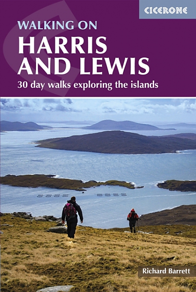
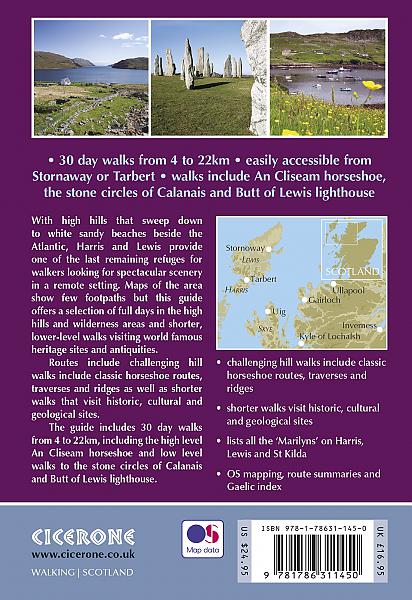
This guidebook describes 30 day walks all over the Isles of Harris and Lewis, in the Outer Hebrides. The walks range from 2 and 14 miles (4 to 22km) in length, and are easily accessible from Stornaway or Tarbet. Routes vary from short strolls to long wilderness hikes, high-level and low-level, and include the An Cliseam horseshoe, visits to ancient historic monuments like the stone circles of Calanais and the famous Butt of Lewis lighthouse, all illustrated with OS 1:50,000 maps and dramatic photography.
The routes take in most of the main summits as well as historical and geographical places of interest. A list of all the Marilyns (British hills of any height with a drop of at least 150m on all sides) on Harris, Lewis and St Kilda is included at the back. Tips are also included about walking on St Kilda, Berneray, Taransay, The Shiant Islands and The Flannan Isles, along with a short Gaelic glossary and route summary table, and advice on practicalities to make the most out of any walking trip on Harris and Lewis.
Engelstalig
EAN: 9781786311450
Auteur(s): Richard barrett
Ingenaaid: paperback,kaft slap
Uitgeverij: Cicerone Press
Verschijningsdatum: 2022
Meest recente editie
Engelstalig
192 pagina's


Op voorraad
Vóór 17 uur op werkdagen besteld, morgen in huis (Nederland)
- Vakkundige klantenservice
- Groot assortiment
- Gratis retourneren binnen 14 dagen
- Aangesloten bij WebwinkelKEUR
€ 21,99
Meer producten die interessant kunnen zijn
Topografische kaarten Hebriden / Skye
Topografische Wandelkaart 23 North Skye Dunvegan & Portree - Landranger Map
Wandelkaart & Fietskaart | Ordnance Survey (OS) Groot-Brittannië
€ 18,99
Topografische Wandelkaart 32 South Skye / Cuillin Hills - Landranger Map
Wandelkaart & Fietskaart | Ordnance Survey (OS) Groot-Brittannië
€ 18,99
Topografische Wandelkaart 33 Loch Alsh / Glen Shiel / Loch Hourn - Landranger Map
Wandelkaart & Fietskaart | Ordnance Survey (OS) Groot-Brittannië
€ 18,99
Topografische Wandelkaart 408 Skye / Trotternish / The Storr Uig - Explorer Map
Wandelkaart & Fietskaart | Ordnance Survey (OS) Groot-Brittannië
€ 18,99
Reisgidsen Hebriden / Skye
Reisgids Outer Hebrides | Bradt Travel Guide
The Western Isles of Scotland from Lewis to Barra
€ 20,99
Reisgids Isle of Skye & de Noordelijke eilanden van de Hebriden | Edicola
€ 24,50
Tijdelijk niet leverbaar
Wegenkaarten Hebriden / Skye
Wandelkaarten Hebriden / Skye
Fietsgidsen Hebriden / Skye
Alpinisme Hebriden / Skye
Klimgids Skye's Cuillin Ridge Traverse | Cicerone Guidebooks
Strategies, advice, detailed topo booklet and 10 classic scrambles
€ 25,99