- Gratis verzending vanaf 30 euro
- Levert in Nederland, België etc.
- Meer dan 30.000 titels
- Vakkundige klantenservice
- Snelle levering
- Veilig en eenvoudig betalen

Direct contact?
Bel +31 (0)6 42428571
maandag t/m vrijdag
van 10 tot 17 uur
Fietsgids The Loire Cycle Route Cicerone guide
From the source in the Massif Central to the Atlantic coast

This guide describes a 1061km cycle route that starts at source of the Loire in the Massif Central mountains of central France and finishes at the Atlantic opposite St Nazaire. The route goes through the heart of France as the Loire becomes the royal river, bounded by extravagant châteaux, fields of Charolais cattle and vineyards. It passes through historic cities like Orléans and Tours, continuing past Angers and France's fourth largest city Nantes.
The 1061km Loire Cycle Route starts at the source of the River Loire in the Massif Central mountains of central France and finishes at the Atlantic opposite St Nazaire. It descends past extinct volcanoes, crater lakes and deep gorges before joining EuroVelo route 6, followed by the fully waymarked Loire à Vélo, France's most popular cycle trail. Following the river downstream in 26 stages, the route is generally downhill or level, often on dedicated traffic-free cycle tracks.
Packed with a wealth of useful information - from practical planning advice to fascinating insights about the river and its surroundings - the guidebook features detailed route descriptions and informative mapping. Details of facilities and places to stay, and a French glossary, are also included.
The route goes through the heart of France as the Loire becomes the royal river, bounded by extravagant châteaux, fields of Charolais cattle and vineyards. It passes through historic cities like Orléans and Tours, continuing past Angers and France's fourth largest city Nantes to finish on the Atlantic coast.
Seasons
The whole route can be cycled when the mountains near the source are snow free, usually April-October. Stages 7-26 can be cycled at any time of year, though April-October is the best period.
Centres
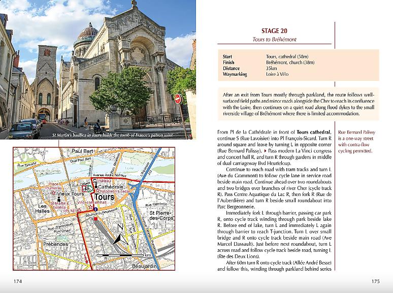
The route passes through Le-Puy-en-Velay, Roanne, Nevers, Orléans, Tours, Saumur, Angers, Nantes and St Nazaire.
Difficulty
Apart from a steep 1000m climb to reach the start and a few ascents and descents in the first six stages this is a straightforward route that is generally downhill or level. Mostly asphalt surfaces in good condition suitable for hybrid or touring cycles. Much of the route follows dedicated off-road cycle tracks, suitable for family cycling, though there are a few short sections where main roads are used.
Must See
Mont Gerbier de Jonc and the volcanic hills of the Ardèche, Le Puy-en-Velay, Charolais hills. After Nevers the route follows La Loire à Vélo, France's most popular cycleway, passing many of the royal châteaux (Chambord, Blois, Chaumont, Villandry, Amboise), vineyards (Sancerre, Touraine, Chinon, Saumur, Anjou, Muscadet), and historic cities (Orléans, Tours, Angers, Nantes) of the Loire Valley.
Engelstalig
EAN: 9781786310835
Uitgeverij: Cicerone Press
Verschijningsdatum: 2022
Meest recente editie
Engelstalig
256 pagina's


Op voorraad
Levertijd 3 dagen (Nederland)
- Vakkundige klantenservice
- Groot assortiment
- Gratis retourneren binnen 14 dagen
- Aangesloten bij WebwinkelKEUR
€ 21,99
Meer producten die interessant kunnen zijn
Wegenkaarten Loire / Centraal Frankrijk

Topografische kaarten Loire / Centraal Frankrijk

Topografische Wandelkaart van Frankrijk 2026SB - St-Gaultier / Rosney La Brenne
Carte de Randonnee | Wandelkaart | Institut Geographique National (IGN) Frankrijk
€ 16,50

Topografische Wandelkaart van Frankrijk 1627SB - Mazieres-en-Gatine / Vasles
Carte de Randonnee | Wandelkaart | Institut Geographique National (IGN) Frankrijk
€ 16,50

Topografische Wandelkaart van Frankrijk 1727SB - Poitiers / Coulombiers
Carte de Randonnee | Wandelkaart | Institut Geographique National (IGN) Frankrijk
€ 16,50

Topografische Wandelkaart van Frankrijk 2121SB - Mer / St-Laurent-Nouan Bracieux / Dhuizon
Carte de Randonnee | Wandelkaart | Institut Geographique National (IGN) Frankrijk
€ 16,50
Tijdelijk niet leverbaar
Fietskaarten Loire / Centraal Frankrijk

Fietskaart 139 Poitiers Chatellerault PNR de la Brenne - IGN Top 100 - Tourisme et Velo
Water- en scheurvaste fietskaart
€ 10,50

Fietskaart 119 Evry Melun Provins Sens Parijs PNR du Gatinais Francais - IGN Top 100 - Tourisme et Velo
Water- en scheurvaste fietskaart
€ 10,50
Fietskaart 132 Cholet Niort Marais Poitevin - IGN Top 100 - Tourisme et Velo
Water- en scheurvaste fietskaart
€ 10,50

Fietskaart 127 Orleans Blois Sologne Val de Loire - IGN Top 100 - Tourisme et Velo
Water- en scheurvaste fietskaart
€ 10,50
Reisgidsen Loire / Centraal Frankrijk

Reisgids Loiredal Marco Polo + Inclusief wegenkaartje
Tijdelijk niet leverbaar
Wandelgidsen Loire / Centraal Frankrijk
Wandelgids PN14 Le Parc Naturelregional Du Vexin ... A Pied | FFRP Topoguides
Ref. PN14 | Entre Paris et Rouen, un parc au patrimoine bâti d'une richesse exceptionnelle.
€ 17,99