- Gratis verzending vanaf 30 euro
- Levert in Nederland, België etc.
- Meer dan 30.000 titels
- Vakkundige klantenservice
- Snelle levering
- Veilig en eenvoudig betalen

Direct contact?
Bel +31 (0)6 42428571
maandag t/m vrijdag
van 10 tot 17 uur
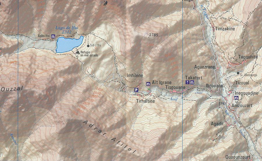
Wandelkaart Toubkal Alto Atlas Hoge Atlas Marokko | Piolet
Oukaimeden, Tacheddirt, Imlil, Toubkal, Lac de Ifni

Prima wandelkaart, met hoogtelijnen. Wandelpaden zijn aangegeven. Geschikt voor GPS, coordinaten zijn vermeld. Berghutten, ski-pistes, klimgebieden plus enkele foto's van het gebied. Water- en scheurvaste wandelkaart. Most of the region shown on the map is within the limits of the Toubkal National Park. Due to its location, only 70 km away from the city Marrakech, it`s the most visited park in all os Morocco. Its a region wiht an exceptional natural and scenic heritage, in an area containing the highest mountains in northem Africa. This area is also home to a diverse collections of vegetacion and animal life, as well as several human sttlements inhabited by Berbers who live in harminy with their environment. We recommend hiring a hiking guide to reach the región because of the treacherous topogragraphy, with numerous valleys and mountains, where it is dificult to navigate. A guide is also useul to facilitate communication wiht the native people. El Bour, Imlil, Oukaimeden, Tioudou, Bou, Iguenouane, Aksoual, Tiziane, Azrou n'Tamadoute, Adrar Iferouane, Tifidern, Takatert, Lago de Ifni, Akioud
Schaal: 1:40.000
Engels Frans
EAN: 9788494708022
Uitgeverij: Editorial Piolet
Meest recente editie
Engels Frans


Op voorraad
Vóór 17 uur besteld, morgen in huis (Nederland)
- Vakkundige klantenservice
- Groot assortiment
- Gratis retourneren binnen 14 dagen
- Aangesloten bij WebwinkelKEUR
€ 16,50
Meer producten die interessant kunnen zijn
4WD Atlas gebergte
Reisgids 4X4 Maroc 1 Pistes du Maroc Haut et Moyen Atlas Marokko | Gandini Guides
€ 37,50
Tijdelijk niet leverbaar