- Gratis verzending vanaf 30 euro
- Levert in Nederland, België etc.
- Meer dan 30.000 titels
- Vakkundige klantenservice
- Snelle levering
- Veilig en eenvoudig betalen

Direct contact?
Bel +31 (0)6 42428571
maandag t/m vrijdag
van 10 tot 17 uur
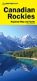
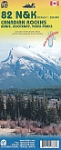
Wegenkaart Best of Icefield Parkway | Gem Trek Publishing
Water- en scheurvaste wegenkaart

The map shows all viewpoints, picnic areas, trailheads, campgrounds, hostels, lodges and other services along the Icefields Parkway, while the brief descriptions in the guide point you to the best of these - the best viewpoints of mountains and lakes, the most interesting points of interest and Parks exhibits, and the best bets for spotting moose, bighorn sheep and mountain goats. Also included are short descriptions of the ten best walks and day hikes along the Icefields Parkway - from ten-minute strolls to more strenuous all-day outings, with the highlights of each trail noted, as well as distance, elevation gain and directions to the trailhead. To make it easier to plan your day, we've also provided information about campgrounds, lodges, visitor centres and other key services along the Icefields Parkway. A mileage chart, area map and elevation profile complete the guide. Everything on the guide is color-keyed to the map, making it easy to find things and get the most out of your drive along the Icefields Parkway.
Schaal: 1:400.000
Engelstalig
EAN: 9781895526974
Uitgeverij: Gem Trek Publishing (Canada)
Serie: Gem Trek Wandelkaart
Meest recente editie
Engelstalig


Op voorraad
Levertijd 3 dagen (Nederland)
- Vakkundige klantenservice
- Groot assortiment
- Gratis retourneren binnen 14 dagen
- Aangesloten bij WebwinkelKEUR
€ 13,50
Verder in deze serie

- Wandelkaart 1 Jasper National Park & Maligne Lake | Gem Trek Publishing
- Wandelkaart 2 Columbia Icefield Guide & Map | Gem Trek Publishing
- Wandelkaart 3 Bow Lake & Saskatchewan Crossing | Gem Trek Publishing
- Wandelkaart 4 Lake Louise & Yoho | Gem Trek Publishing
- Wandelkaart 5 Banff & Mount Assiniboine | Gem Trek Publishing
- Wandelkaart 6 Canmore & Kananaskis Village | Gem Trek Publishing
- Wandelkaart 7 Kananaskis Lakes (Peter Lougheed Provincial Park) | Gem Trek Publishing
- Wandelkaart 8 Bragg Creek & Sheep Valley | Gem Trek Publishing
- Wandelkaart 8 Bragg Creek & Sheep Valley | Gem Trek Publishing
- Wandelkaart 9 Highwood & Cataract Creek | Gem Trek Publishing
- Wandelkaart 10 Kootenay National Park | Gem Trek Publishing
- Wandelkaart 10 Kootenay National Park | Gem Trek Publishing
- Wandelkaart 11 Banff Up-Close | Gem Trek Publishing
- Wandelkaart 12 Best of Jasper | Gem Trek Publishing
- Wandelkaart 13 Best of Lake Louise | Gem Trek Publishing
- Wandelkaart 14 Lake O'hara | Gem Trek Publishing
- Wandelkaart 16 Waterton Lakes National Park | Gem Trek Publishing
- Wandelkaart 17 Banff: Egypt Lake | Gem Trek Map
- Wandelkaart Jasper National Park Map and Guide | Gem Trek Publishing
Meer producten die interessant kunnen zijn
Wegenkaarten British-Columbia
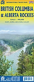
Wegenkaart - landkaart British Columbia & Alberta Rockies | ITMB
Banff Jasper Lake Louise Calgary
€ 13,50
Wandelgidsen British-Columbia
Wildlife-gidsen British-Columbia
Reisgidsen British-Columbia
Topografische kaarten British-Columbia
Topografische Wandelkaart Canadian Rockies Banff, Kootenay, Yoho Park 82J/K/N/O - ITMB Map
Water- en scheurvaste wandelkaart
€ 13,50