- Gratis verzending vanaf 30 euro
- Levert in Nederland, België etc.
- Meer dan 30.000 titels
- Vakkundige klantenservice
- Snelle levering
- Veilig en eenvoudig betalen

Direct contact?
Bel +31 (0)6 42428571
maandag t/m vrijdag
van 10 tot 17 uur
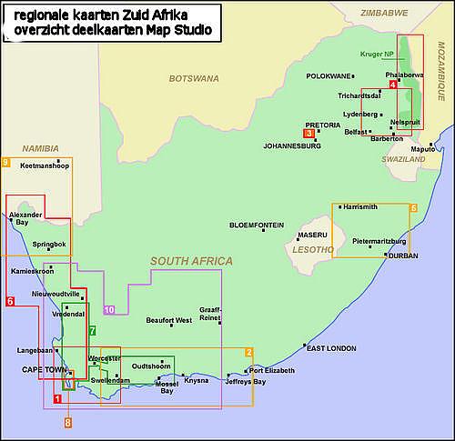
Wegenkaart - Landkaart 10 Western Cape Westkaap | MapStudio

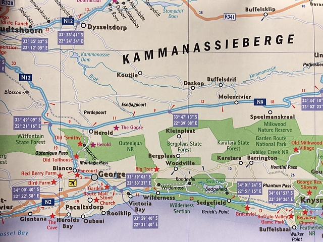
Road map of the Western Cape Province with an enlargement for the Cape Peninsula and 27 street plans of the central areas in main towns. The map is annotated numerous places of interest, vineyards, etc. GPS coordinates are provides for main road junctions. The map is double-sided, dividing the province east/west, and shows its road and rail networks. Unsurfaced minor roads and selected 4WD tracks are included and GPS coordinates are provided for over 150 road junctions. Railways are shown with stations. Numerous places of interest are highlighted, including wineries, historical sites, nature reserves, bird watching sites, etc. Topography is indicated only by mountain passes marked along the roads and occasional spot heights. Nature reserves and other protected areas are prominently marked. The map is indexed and in addition to the tables with GPS coordinates for road junctions has latitude and longitude margin ticks at intervals of 1°. An enlargement shows the Cape Peninsula in greater detail. Street plans, annotated with places of interest show central areas in 27 main towns, including Cape Town. Also provided is a list of useful contact details for tourist offices, wineries, etc.
Schaal: 1:500.000
Engelstalig
EAN: 9781770269958
Uitgeverij: MapStudio (Zuid-Afrika)
Serie: MapStudio Regionaal
Meest recente editie
Engelstalig

Op voorraad
Levertijd 3 dagen (Nederland)
- Vakkundige klantenservice
- Groot assortiment
- Gratis retourneren binnen 14 dagen
- Aangesloten bij WebwinkelKEUR
€ 16,50
Verder in deze serie

- Wegenkaart - Landkaart 1 Kaapstad & omgeving Cape Town | MapStudio
- Wegenkaart - Landkaart 2 Garden Route & Route 62 | MapStudio
- Wegenkaart - Landkaart 4 Mpumalanga, Kruger National Park & Panorama Route | MapStudio
- Wegenkaart - Landkaart 5 Kwazulu-Natal | MapStudio
- Wegenkaart - Landkaart 7 Winelands of the Western Cape | MapStudio
Meer producten die interessant kunnen zijn
Reisgidsen Zuid-Afrika


Natuurgidsen Zuid-Afrika

Wegenatlassen Zuid-Afrika

Taalgidsen Zuid-Afrika
Wandelgidsen Zuid-Afrika

Wandelgids Zuid-Afrika Südafrika West Rother Wanderführer | Rother Bergverlag
65 wandelingen in den Kap-Provinzen
€ 18,99