- Gratis verzending vanaf 30 euro
- Levert in Nederland, België etc.
- Meer dan 30.000 titels
- Vakkundige klantenservice
- Snelle levering
- Veilig en eenvoudig betalen

Direct contact?
Bel +31 (0)6 42428571
maandag t/m vrijdag
van 10 tot 17 uur
Wandelgids 60 Lake District Pathfinder Guide
Pathfinder Guide 60 | Met Ordanance Survey kaarten
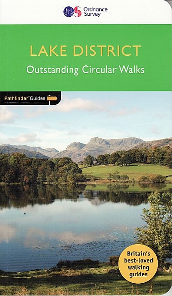
Deze Pathfinder Guide is een goed uitgevoerde gids met verschillende wandelingen in Groot-Britannië. De gids bevat naast goede topografische kaarten van de Britse topografische dienst (Ordanance Survey) ook beschrijvingen van het landschap, de cultuur en/of de flora en fauna. Verder is de gids voorzien van praktische informatie zoals startpunten, verwachte wandeltijd, restaurants en cafés voor onderweg. Pathfinder Lake District covering Coniston, Kewswick and Devoke Water. This selection offers interest, regional variety and balance of routes in the Lake District providing the best walks in the area. From an easy stroll through Buttermere to the much more challenging walks in Rosthwaite and Stonethwaite this volume contains something for everyone.
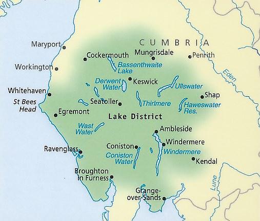
Covering walks through the whole of the Lake District both popular and little know scenic routes including Bowfell, Wetherlan and the Langdale Valleys.
* 28 great walks in the Lake District from 3 to 10 miles
* Clear, large scale Ordnance Survey route maps
* GPS reference for all Lake District waypoints
* Where to park, good pubs and places of interest en route
All routes have been fully researched and written by expert outdoor writers, with beautiful photography of scenes from the walks.
Pathfinder Guides are Britain's best loved walking guides. Made with durable covers, they are the perfect companion for countryside walks throughout Britain. Each title features circular walks with easy-to-follow route descriptions, large-scale Ordnance Survey route maps and GPS waypoints.With over 70 titles in the series, they offer essential information for walkers throughout the country.
Engelstalig
EAN: 9780319090169
Uitgeverij: Ordnance Survey Books
Serie: Pathfinder
Verschijningsdatum: 2016
Meest recente editie
Engelstalig
95 pagina's

Op voorraad
Levertijd 3 dagen (Nederland)
- Vakkundige klantenservice
- Groot assortiment
- Gratis retourneren binnen 14 dagen
- Aangesloten bij WebwinkelKEUR
€ 17,99
Verder in deze serie
- Wandelgids 01 South Devon and Dartmoor Pathfinder Guide
- Wandelgids 01 Yorkshire Dales Pathfinder Guide (Short Walks)
- Wandelgids 02 Peak District Pathfinder Guide (Short Walks)
- Wandelgids 03 Isle of Skye Pathfinder Guide
- Wandelgids 03 Lake District Pathfinder Guide (Short Walks)
- Wandelgids 04 Cairngorms Pathfinder Guide
- Wandelgids 04 Cotswolds Pathfinder Guide (Short Walks)
- Wandelgids 06 Cotswolds Pathfinder Guide
- Wandelgids 07 Fort William & Glen Coe Walks Pathfinder Guide
- Wandelgids 08 Dartmoor Pathfinder Guide (Short Walks)
- Wandelgids 08 Kent Pathfinder Guide
- Wandelgids 09 Exmoor and the Quantocks Pathfinder Guide
- Wandelgids 10 Snowdonia Pathfinder Guide
- Wandelgids 11 Dorset Pathfinder Guide
- Wandelgids 12 New Forest, Hampshire and South Downs Pathfinder Guide
- Wandelgids 13 North York Moors Pathfinder Guide (Short Walks)
- Wandelgids 14 Shropshire and Staffordshire Pathfinder Guide
- Wandelgids 14 Snowdonia Pathfinder Guide (Short Walks)
- Wandelgids 15 Yorkshire Dales Pathfinder Guide
- Wandelgids 18 Brecon Beacons Pathfinder Guide
- Wandelgids 19 Dumfries & Galloway Pathfinder Guide
- Wandelgids 21 Exmoor Pathfinder Guide (Short Walks)
- Wandelgids 21Somerset the Mendips Wiltshire Pathfinder Guide
- Wandelgids 23 Loch Lomond, The Trossachs and Stirling Pathfinder Guide
- Wandelgids 23 New Forest NP Pathfinder Guide (Short Walks)
- Wandelgids 25 Thames Valley and Chilterns Pathfinder Guide
- Wandelgids 26 Dartmoor Pathfinder Guide
- Wandelgids 27 Isle of Wight Pathfinder Guide (Short Walks)
- Wandelgids 27 Perthshire, Angus & Fife Pathfinder Guide
- Wandelgids 28 North York Moors Pathfinder Guide
- Wandelgids 29 Devon South Pathfinder Guide (Short Walks)
- Wandelgids 29 Wye Valley & Forrest of Dean Pathfinder Guide
- Wandelgids 30 Loch Ness & Iverness Pathfinder Guide
- Wandelgids 32 Wales North & Snowdonia Pathfinder Guide
- Wandelgids 34 Pembrokeshire and Carmarthenshire Pathfinder Guide
- Wandelgids 35 Northumberland & the Scottish Borders Pathfinder Guide
- Wandelgids 39 Durham, North Pennines & Tyne & Wear Pathfinder Guide
- Wandelgids 41 Mid Wales Pathfinder Guide
- Wandelgids 42 Cheshire Pathfinder Guide
- Wandelgids 45 Norfolk Pathfinder Guide
- Wandelgids 46 Aberdeen / Royal Deeside Pathfinder Guide
- Wandelgids 47 Brecon Beacons Pathfinder Guide (Short Walks)
- Wandelgids 47 Edinburgh, Pentlands & the Lothians Pathfinder Guide
- Wandelgids 48 Suffolk Pathfinder Guide
- Wandelgids 49 Vale of York and the Yorkshire Wolds Pathfinder Guide
- Wandelgids 50 Lincolnshire & the Wolds Pathfinder Guide
- Wandelgids 53 Lancashire Pathfinder Guide
- Wandelgids 54 Hertfordshire and Bedfordshire Pathfinder Guide
- Wandelgids 55 Gower / Swansea / Cardiff Pathfinder Guide
- Wandelgids 63 Peak District Pathfinder Guide
- Wandelgids 64 South Pennines Pathfinder Guide
- Wandelgids 67 Downs South NP & East Sussex Pathfinder Guide
- Wandelgids 68 Devon North & Mid Pathfinder Guide
- Wandelgids 74 Malverns to Warwickshire Pathfinder Guide
Meer producten die interessant kunnen zijn
Wegenkaarten Noord-Engeland


Wegenkaart - Landkaart 502 Noord-Engeland - Michelin Regional
Northern England, the Midlands 502
€ 11,50


Wegenkaart - Landkaart Northern Engeland Noord-Engeland & the Midlands - World Mapping Project (Reise Know-How)
Water- en scheurvaste wegenkaart
€ 13,50
Wandelkaarten Noord-Engeland

Wandelkaartgids Hadrian's Wall Path
All the Ordnance Survey mapping needed for Hadrian's Wall Path
€ 13,50

Wandelkaart Hadrian's Wall Path - National Trail Maps | Harvey Maps
Water- en scheurvaste wandelkaart
€ 25,99

Wandelkaart Cleveland Way - National Trail Maps | Harvey Maps
Water- en scheurvaste wandelkaart
€ 25,99

Wandelkaart Coast to Coast - St. Bees to Robin Hood's Bay - National Trail Maps | Harvey Maps
Water- en scheurvaste wandelkaart
€ 25,99
Topografische kaarten Noord-Engeland

Topografische Wandelkaart OL27 van Groot-Brittannië (1:25.000) North York Moors Eastern area - Explorer Map OL 27
Wandelkaart | Ordnance Survey (OS) Groot-Brittannië
€ 18,99

Topografische Wandelkaart 278 Sheffield / Barnsley Rotherham - Explorer Map
Wandelkaart & Fietskaart | Ordnance Survey (OS) Groot-Brittannië
€ 18,99
Tijdelijk niet leverbaar

Topografische Wandelkaart 290 York / Selby / Tadcaster - Explorer Map
Wandelkaart & Fietskaart | Ordnance Survey (OS) Groot-Brittannië
€ 18,99
Tijdelijk niet leverbaar

Topografische Wandelkaart 80 Cheviot Hills & Kielder Water - Landranger Map
Wandelkaart & Fietskaart | Ordnance Survey (OS) Groot-Brittannië
€ 18,99
Reisgidsen Noord-Engeland


Reisgids Slow North York Moors & Yorkshire Wolds Bradt Travel Guide
Moors, Dales And Coast, Including Yorklocal, Characterful Guides
€ 21,90

