- Gratis verzending vanaf 30 euro
- Levert in Nederland, België etc.
- Meer dan 30.000 titels
- Vakkundige klantenservice
- Snelle levering
- Veilig en eenvoudig betalen

Direct contact?
Bel +31 (0)6 42428571
maandag t/m vrijdag
van 10 tot 17 uur
Reisgids Yorkshire Rough Guide
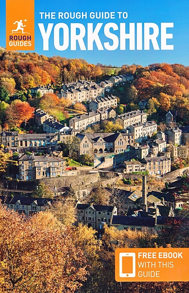
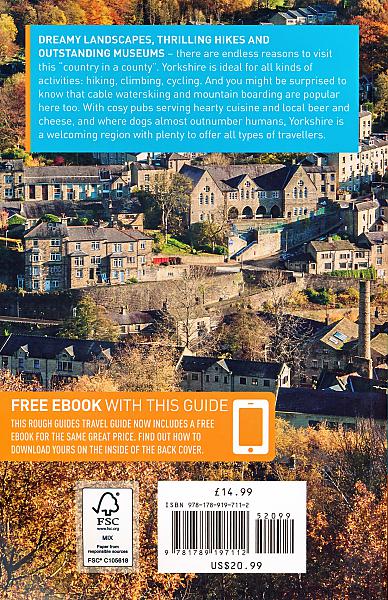
De Rough Guide is een zeer degelijke, uitgebreide en informatieve reisgids voor iedere type reiziger: van backpacker tot cultuurreiziger. De Rough Guide staat bekend om de degelijke en goed onderzochte achtergrondinformatie en de goede ordening van verschillende onderwerpen. Voor veel gebieden is de Rough Guide een goed, soms zelfs een beter, alternatief voor de populaire Lonely Planet. The Rough Guide to Yorkshire is the first comprehensive guidebook to England's largest county. It includes comprehensive coverage of the county, from the ruggedly beautiful Dales and Moors and magnificent North Sea coast, historic York to the multi-cultural cities of Leeds and Sheffield, the resurgent port of Hull to all the market towns and rural villages in between. Take your pick of great stately homes to visit, of cathedrals and churches and monastic ruins, of steam railways and seaside resorts, of world-class historical and industrial museums, of hotels and places where you can consume good Yorkshire food and ale. Accurate maps and comprehensive practical information help you get under the skin of the region, whilst stunning photography and a full-colour introduction make this your ultimate travelling companion to Yorkshire. Whether you're on holiday, on business, visiting family and friends or just passing through – even if you've lived in Yorkshire all your life – The Rough Guide to Yorkshire will ensure that you don't miss a thing.
Engelstalig
EAN: 9781789197112
Uitgeverij: Rough Guide
Verschijningsdatum: 2022
Meest recente editie
Engelstalig
328 pagina's
Op voorraad
Vóór 17 uur besteld, morgen in huis (Nederland)
- Vakkundige klantenservice
- Groot assortiment
- Gratis retourneren binnen 14 dagen
- Aangesloten bij WebwinkelKEUR
€ 18,99
Meer producten die interessant kunnen zijn
Wandelgidsen Noord-Engeland
Wandelgids 60 Lake District Pathfinder Guide
Pathfinder Guide 60 | Met Ordanance Survey kaarten
€ 17,99
Wandelgids Coast to Coast path Two-way trekking guide | Knife Edge
St Bees to Robin Hood's Bay
€ 20,99
Wandelgids Coast to Coast Walk Cicerone Guidebooks
From St Bees Head in Cumbria to Robin Hood’s Bay on Yorkshire’s
€ 22,99
Wegenkaarten Noord-Engeland


Wegenkaart - Landkaart 502 Noord-Engeland - Michelin Regional
Northern England, the Midlands 502
€ 11,50


Wegenkaart - Landkaart Northern Engeland Noord-Engeland & the Midlands - World Mapping Project (Reise Know-How)
Water- en scheurvaste wegenkaart
€ 13,50
Wandelkaarten Noord-Engeland

Wandelkaartgids Hadrian's Wall Path
All the Ordnance Survey mapping needed for Hadrian's Wall Path
€ 13,50

Wandelkaart Hadrian's Wall Path - National Trail Maps | Harvey Maps
Water- en scheurvaste wandelkaart
€ 25,99

Wandelkaart Cleveland Way - National Trail Maps | Harvey Maps
Water- en scheurvaste wandelkaart
€ 25,99

Wandelkaart Coast to Coast - St. Bees to Robin Hood's Bay - National Trail Maps | Harvey Maps
Water- en scheurvaste wandelkaart
€ 25,99
Topografische kaarten Noord-Engeland

Topografische Wandelkaart OL27 van Groot-Brittannië (1:25.000) North York Moors Eastern area - Explorer Map OL 27
Wandelkaart | Ordnance Survey (OS) Groot-Brittannië
€ 18,99

Topografische Wandelkaart 278 Sheffield / Barnsley Rotherham - Explorer Map
Wandelkaart & Fietskaart | Ordnance Survey (OS) Groot-Brittannië
€ 18,99
Tijdelijk niet leverbaar

Topografische Wandelkaart 290 York / Selby / Tadcaster - Explorer Map
Wandelkaart & Fietskaart | Ordnance Survey (OS) Groot-Brittannië
€ 18,99
Tijdelijk niet leverbaar

Topografische Wandelkaart 80 Cheviot Hills & Kielder Water - Landranger Map
Wandelkaart & Fietskaart | Ordnance Survey (OS) Groot-Brittannië
€ 18,99
