- Gratis verzending vanaf 30 euro
- Levert in Nederland, België etc.
- Meer dan 30.000 titels
- Vakkundige klantenservice
- Snelle levering
- Veilig en eenvoudig betalen

Direct contact?
Bel +31 (0)6 42428571
maandag t/m vrijdag
van 10 tot 17 uur
Reisgids Slow North York Moors & Yorkshire Wolds Bradt Travel Guide
Moors, Dales And Coast, Including Yorklocal, Characterful Guides
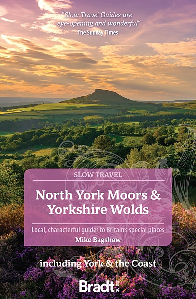
This new, thoroughly updated second edition of Bradt's North York Moors and Yorkshire Wolds, part of the distinctive 'Slow travel' series of guides to UK regions, remains the only full-blown standalone guide available to this region of contrasts, from the magnificent cliffs and beaches of the Heritage Coast and rolling hills of the North York Moors to the tranquil chalk downland of the Wolds. Nestled at the heart of it all is the ancient historic city of York, with its stunning Minster, the largest Gothic cathedral in Northern Europe. As well as featuring all the main sights, Bradt's North York Moors and Yorkshire Wolds includes places and aspects of the region not detailed by other guidebooks and, while making a virtue of being selective, nonetheless covers the whole region in considerable detail. It also includes personal anecdotes and the views of local people as well as tapping into the Yorkshire-based author's considerable knowledge of the region, especially his experiences as an outdoor enthusiast, naturalist and beer connoisseur. With Bradt's North York Moors and Yorkshire Wolds, discover what makes this area tick. The annual Tour de Yorkshire has helped to establish the region as a biking Mecca, while the Yorkshire Nature Triangle in the east is renowned for its birds and wildlife, from adders to barn owls, otters to dolphins. Wildlife lovers will also find details of whale-watching tours. Included in the guide is information on the 10 long-distance paths which cross the area, plus tips on the sandy beaches and rocky coves that make this an ideal family destination. Local food and drink, from seafood to meats, cheeses and breweries, is covered, too. Also included are details of festivals, steam train journeys as featured in the Harry Potter films, the Georgian opulence of Castle Howard as featured in Brideshead Revisited, sea-bird colonies along the Heritage Coast, the only mainland colony of gannets in England at Bempton Cliffs, and the tallest standing stone in Britain. Written in an entertaining style combining personal narrative with authoritative information, Bradt's North York Moors and Yorkshire Wolds has all the most up-to-date information you could need for a successful visit.
Engelstalig
EAN: 9781804690093
Auteur(s): Mike bagshaw
Ingenaaid: paperback,kaft slap
Uitgeverij: Bradt Travelguides
Serie: Bradt Travel Guides and Alastair Sawday
Verschijningsdatum: 2023
Meest recente editie
Engelstalig
256 pagina's
Op voorraad
Overmorgen in huis (Nederland)
- Vakkundige klantenservice
- Groot assortiment
- Gratis retourneren binnen 14 dagen
- Aangesloten bij WebwinkelKEUR
€ 21,90
Verder in deze serie
Meer producten die interessant kunnen zijn
Wandelgidsen Noord-Engeland
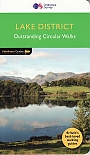
Wandelgids 60 Lake District Pathfinder Guide
Pathfinder Guide 60 | Met Ordanance Survey kaarten
€ 17,99
Wandelgids Coast to Coast path Two-way trekking guide | Knife Edge
St Bees to Robin Hood's Bay
€ 20,99
Wandelgids Coast to Coast Walk Cicerone Guidebooks
From St Bees Head in Cumbria to Robin Hood’s Bay on Yorkshire’s
€ 22,99
Wegenkaarten Noord-Engeland


Wegenkaart - Landkaart 502 Noord-Engeland - Michelin Regional
Northern England, the Midlands 502
€ 11,50


Wegenkaart - Landkaart Northern Engeland Noord-Engeland & the Midlands - World Mapping Project (Reise Know-How)
Water- en scheurvaste wegenkaart
€ 13,50
Wandelkaarten Noord-Engeland

Wandelkaartgids Hadrian's Wall Path
All the Ordnance Survey mapping needed for Hadrian's Wall Path
€ 13,50

Wandelkaart Hadrian's Wall Path - National Trail Maps | Harvey Maps
Water- en scheurvaste wandelkaart
€ 25,99

Wandelkaart Cleveland Way - National Trail Maps | Harvey Maps
Water- en scheurvaste wandelkaart
€ 25,99

Wandelkaart Coast to Coast - St. Bees to Robin Hood's Bay - National Trail Maps | Harvey Maps
Water- en scheurvaste wandelkaart
€ 25,99
Topografische kaarten Noord-Engeland

Topografische Wandelkaart OL27 van Groot-Brittannië (1:25.000) North York Moors Eastern area - Explorer Map OL 27
Wandelkaart | Ordnance Survey (OS) Groot-Brittannië
€ 18,99

Topografische Wandelkaart 278 Sheffield / Barnsley Rotherham - Explorer Map
Wandelkaart & Fietskaart | Ordnance Survey (OS) Groot-Brittannië
€ 18,99
Tijdelijk niet leverbaar

Topografische Wandelkaart 290 York / Selby / Tadcaster - Explorer Map
Wandelkaart & Fietskaart | Ordnance Survey (OS) Groot-Brittannië
€ 18,99
Tijdelijk niet leverbaar

Topografische Wandelkaart 80 Cheviot Hills & Kielder Water - Landranger Map
Wandelkaart & Fietskaart | Ordnance Survey (OS) Groot-Brittannië
€ 18,99
