- Gratis verzending vanaf 30 euro
- Levert in Nederland, België etc.
- Meer dan 30.000 titels
- Vakkundige klantenservice
- Snelle levering
- Veilig en eenvoudig betalen

Direct contact?
Bel +31 (0)6 42428571
maandag t/m vrijdag
van 10 tot 17 uur
Wandelgids The Thames Path Cicerone Guidebooks
National Trail from London to the river's source in Gloucestershire
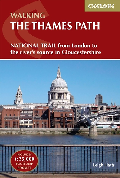
A guidebook to walking the Thames Path, a 182-mile National Trail from the Woolwich Foot Tunnel in London to the river's source in near Cirencester, passing from central London through Windsor, Henley, and Oxford, and rural countryside. Described in 20 sections, of between 4 and 16 miles (6.5-32km), it is an mainly flat route with good access by public transport and typically takes two weeks to walk. On its way it passes historic sites such as Greenwich, Kew Gardens, Hampton Court, Runnymede, Windsor Castle and Oxford.
This guidebook features complete OS 1:50,000 scale mapping of the route and comprehensive information about accommodation, facilities, refreshments and transport links for each stage of the route. It is crammed with fascinating details about the places and features passed along the way. A separate pocket-sized map booklet is also included showing the full route on 1:25,000 scale OS maps, providing all the mapping needed to complete the trail.
The Thames Path is an easy riverside walk that discovers the constantly changing character of the River Thames.
Engelstalig
EAN: 9781786311481
Auteur(s): Leigh hatts
Uitgeverij: Cicerone Press
Serie: National Trail
Verschijningsdatum: 2023
Meest recente editie
Engelstalig
224 pagina's


Op voorraad
Levertijd 3 dagen (Nederland)
- Vakkundige klantenservice
- Groot assortiment
- Gratis retourneren binnen 14 dagen
- Aangesloten bij WebwinkelKEUR
€ 22,99
Verder in deze serie
- Wandelgids Ridgeway Cicerone Guidebooks
- Wandelgids South Downs Way described east–west and west–east | Cicerone
- Wandelgids St Oswald's Way and St Cuthbert's Way | Cicerone
- Wandelgids The Cotswolds Way Cicerone Guidebooks
- Wandelgids The Great Glen Way Cicerone Guidebooks
- Wandelgids The Great Glen Way | Cicerone
- Wandelgids The North Downs Way | Cicerone
- Wandelgids The South West Coast Path (Zoutpad) Cicerone Guidebooks
- Wandelgids The Speyside Way Cicerone Guidebooks
- Wandelgids The West Highland Way Cicerone Guidebooks
- Wandelkaartgids South West Coast Path Map Booklet - Minehead to St Ives deel 1(Zoutpad) | Cicerone
- Wandelkaartgids South West Coast Path Map Booklet - Plymouth to Poole deel 3 (Zoutpad) | Cicerone
- Wandelkaartgids South West Coast Path Map Booklet - St Ives to Plymouth deel 2 (Zoutpad) | Cicerone
- Wandelkaartgids The North Downs Way Booklet | Cicerone
- Wandelkaartgids The Thames Path Map Booklet | Cicerone
- Wandelkaartgids Walking the Cotswold Way | Cicerone
- Wandelkaartgids West Highland Way Map Booklet | Cicerone
Meer producten die interessant kunnen zijn
Wegenkaarten Zuid-Oost Engeland / Kent


Wegenkaart - Landkaart 504 Zuid-Oost Engeland Kent Sussex - Michelin Regional
South East England, the Midlands, East Anglia 504
€ 11,50

Topografische kaarten Zuid-Oost Engeland / Kent

Topografische Wandelkaart 124 Hastings / Bexhill - Explorer Map
Wandelkaart & Fietskaart | Ordnance Survey (OS) Groot-Brittannië
€ 18,99

Topografische Wandelkaart OL25 van Groot-Brittannië (1:25.000) Eastbourne & Beachy Head Newhaven, Seaford Explorer Map OL 25
Wandelkaart | Ordnance Survey (OS) Groot-Brittannië
€ 18,99

Topografische Wandelkaart 136 High Weald / Royal Tunbridge Wells - Explorer Map
Wandelkaart & Fietskaart | Ordnance Survey (OS) Groot-Brittannië
€ 18,99

Topografische Wandelkaart 138 Dover / Folkstone / Hythe - Explorer Map
Wandelkaart & Fietskaart | Ordnance Survey (OS) Groot-Brittannië
€ 18,99
Reisgidsen Zuid-Oost Engeland / Kent

Fietskaarten Zuid-Oost Engeland / Kent

Fietskaart 5 Kent The High Weald and Kent Downs Cycle Maps UK | Cordee
Water- en scheurvaste fietskaart
Tijdelijk niet leverbaar