- Gratis verzending vanaf 30 euro
- Levert in Nederland, België etc.
- Meer dan 30.000 titels
- Vakkundige klantenservice
- Snelle levering
- Veilig en eenvoudig betalen

Direct contact?
Bel +31 (0)6 42428571
maandag t/m vrijdag
van 10 tot 17 uur
Wandelgids St Oswald's Way and St Cuthbert's Way | Cicerone
Heavenfield and Cresswell to Holy Island
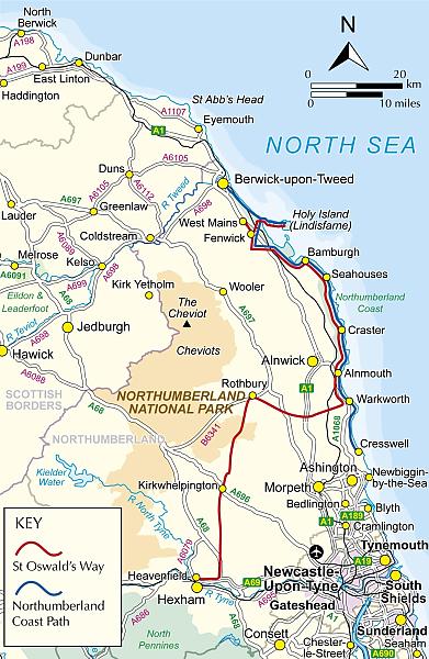
This guidebook describes the St Oswald's Way and Northumberland Coast Paths, both long-distance trails through Northumberland. St Oswald's Way (156km, 97 miles) begins in Heavenfield and traverses parts of Northumberland National Park and visits Hadrian's Wall, the Simonside Hills and the beautiful Coquet Valley, before continuing up the coast to Lindisfarne (Holy Island). The Northumberland Coast Path (100km, 62 miles) takes in the whole of the Northumberland Coast AONB with its breathtaking coastal scenery and birdlife.
Both trails converge on Holy Island, with the Coast Path continuing up to Berwick-upon-Tweed. Each trail can be walked in a week. The guide includes practical advice on when to go and what to take, and information on the region, its weather, wildlife, history and heritage.
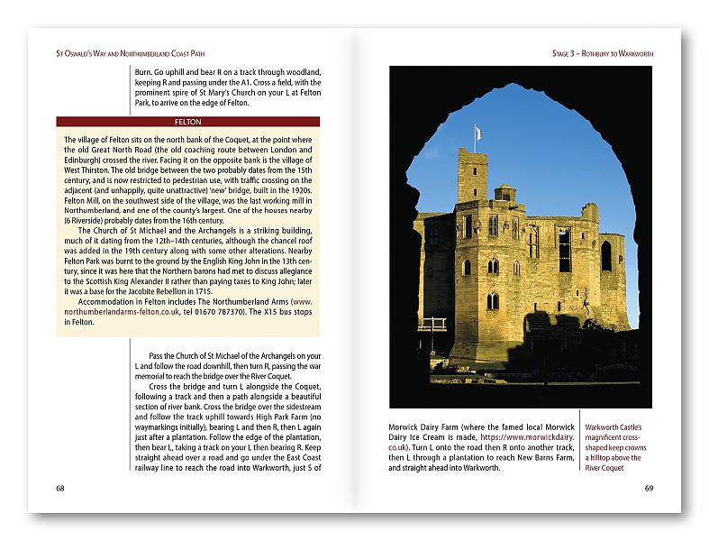
Detailed route descriptions and clear, step-by-step instructions are accompanied by 1:50K OS mapping. Public transport options and accommodation listings are also given. Described as the cradle of Christianity in England, Northumberland's history is long and varied and the trails reflect this with visits to some magnificent architecture - rambling castles, Norman churches, medieval abbeys - as well as sites of enormous archaeological and geological interest, quiet villages and Sites of Special Scientific Interest.
From rugged hills to coastal dunes this is one of Britain's most beautiful landscapes for walking and backpacking far away from it all.
EAN: 9781786311559
Uitgeverij: Cicerone Press
Serie: Cicerone National Trail
Verschijningsdatum: 2023
Meest recente editie
136 pagina's


Op voorraad
Overmorgen in huis (Nederland)
- Vakkundige klantenservice
- Groot assortiment
- Gratis retourneren binnen 14 dagen
- Aangesloten bij WebwinkelKEUR
€ 22,99
Meer producten die interessant kunnen zijn
Wegenkaarten Noord-Engeland


Wegenkaart - Landkaart 502 Noord-Engeland - Michelin Regional
Northern England, the Midlands 502
€ 11,50


Wegenkaart - Landkaart Northern Engeland Noord-Engeland & the Midlands - World Mapping Project (Reise Know-How)
Water- en scheurvaste wegenkaart
€ 13,50
Wandelkaarten Noord-Engeland

Wandelkaartgids Hadrian's Wall Path
All the Ordnance Survey mapping needed for Hadrian's Wall Path
€ 13,50

Wandelkaart Hadrian's Wall Path - National Trail Maps | Harvey Maps
Water- en scheurvaste wandelkaart
€ 25,99

Wandelkaart Cleveland Way - National Trail Maps | Harvey Maps
Water- en scheurvaste wandelkaart
€ 25,99

Wandelkaart Coast to Coast - St. Bees to Robin Hood's Bay - National Trail Maps | Harvey Maps
Water- en scheurvaste wandelkaart
€ 25,99
Topografische kaarten Noord-Engeland

Topografische Wandelkaart OL27 van Groot-Brittannië (1:25.000) North York Moors Eastern area - Explorer Map OL 27
Wandelkaart | Ordnance Survey (OS) Groot-Brittannië
€ 18,99

Topografische Wandelkaart 278 Sheffield / Barnsley Rotherham - Explorer Map
Wandelkaart & Fietskaart | Ordnance Survey (OS) Groot-Brittannië
€ 18,99
Tijdelijk niet leverbaar

Topografische Wandelkaart 290 York / Selby / Tadcaster - Explorer Map
Wandelkaart & Fietskaart | Ordnance Survey (OS) Groot-Brittannië
€ 18,99
Tijdelijk niet leverbaar

Topografische Wandelkaart 80 Cheviot Hills & Kielder Water - Landranger Map
Wandelkaart & Fietskaart | Ordnance Survey (OS) Groot-Brittannië
€ 18,99
Reisgidsen Noord-Engeland


Reisgids Slow North York Moors & Yorkshire Wolds Bradt Travel Guide
Moors, Dales And Coast, Including Yorklocal, Characterful Guides
€ 21,90

