- Gratis verzending vanaf 30 euro
- Levert in Nederland, België etc.
- Meer dan 30.000 titels
- Vakkundige klantenservice
- Snelle levering
- Veilig en eenvoudig betalen

Direct contact?
Bel +31 (0)6 42428571
maandag t/m vrijdag
van 10 tot 17 uur
Wandelgids Coast to Coast path Two-way trekking guide | Knife Edge
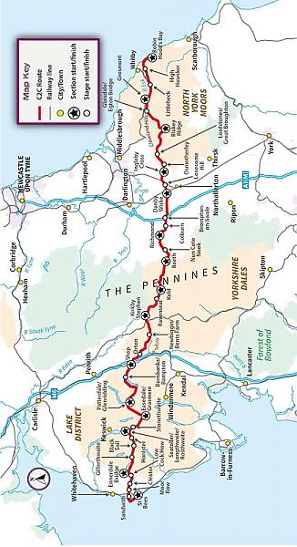
St Bees to Robin Hood's Bay

The definitive two-way guide to the Coast to Coast Path: both eastbound and westbound routes are described in full.
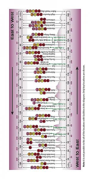
Real Maps: Full Ordnance Survey mapping inside (1:25,000). All accommodation is numbered and marked on the maps.
19 different itineraries: schedules of 11, 12, 13, 14, 15, 16, 17, 18 and 19 days for hikers and runners. Includes both eastbound and westbound itineraries. Difficult calculations of time, distance and altitude gain/loss are done for you.
Also includes: Detailed information on equipment and travelling light
Full accommodation listings: the best pubs, B&Bs and hotels
Detailed section on camping, including wild camping
Everything the trekker needs to know: route, costs, difficulty, weather, travel, and more
Essential info for both self-guided and guided trekkers
Information on plants and wildlife
Numbered waypoints linking the Real Maps to our clear descriptions
Engelstalig
EAN: 9781912933143
Uitgeverij: Knife Edge
Verschijningsdatum: 2022
Meest recente editie
Engelstalig
205 pagina's


Op voorraad
Vóór 17 uur besteld, morgen in huis (Nederland)
- Vakkundige klantenservice
- Groot assortiment
- Gratis retourneren binnen 14 dagen
- Aangesloten bij WebwinkelKEUR
€ 20,99
Meer producten die interessant kunnen zijn
Wegenkaarten Noord-Engeland


Wegenkaart - Landkaart 502 Noord-Engeland - Michelin Regional
Northern England, the Midlands 502
€ 11,50


Wegenkaart - Landkaart Northern Engeland Noord-Engeland & the Midlands - World Mapping Project (Reise Know-How)
Water- en scheurvaste wegenkaart
€ 13,50
Wandelkaarten Noord-Engeland

Wandelkaartgids Hadrian's Wall Path
All the Ordnance Survey mapping needed for Hadrian's Wall Path
€ 13,50

Wandelkaart Hadrian's Wall Path - National Trail Maps | Harvey Maps
Water- en scheurvaste wandelkaart
€ 25,99

Wandelkaart Cleveland Way - National Trail Maps | Harvey Maps
Water- en scheurvaste wandelkaart
€ 25,99

Wandelkaart Coast to Coast - St. Bees to Robin Hood's Bay - National Trail Maps | Harvey Maps
Water- en scheurvaste wandelkaart
€ 25,99
Topografische kaarten Noord-Engeland

Topografische Wandelkaart OL27 van Groot-Brittannië (1:25.000) North York Moors Eastern area - Explorer Map OL 27
Wandelkaart | Ordnance Survey (OS) Groot-Brittannië
€ 18,99

Topografische Wandelkaart 278 Sheffield / Barnsley Rotherham - Explorer Map
Wandelkaart & Fietskaart | Ordnance Survey (OS) Groot-Brittannië
€ 18,99
Tijdelijk niet leverbaar

Topografische Wandelkaart 290 York / Selby / Tadcaster - Explorer Map
Wandelkaart & Fietskaart | Ordnance Survey (OS) Groot-Brittannië
€ 18,99
Tijdelijk niet leverbaar

Topografische Wandelkaart 80 Cheviot Hills & Kielder Water - Landranger Map
Wandelkaart & Fietskaart | Ordnance Survey (OS) Groot-Brittannië
€ 18,99
Reisgidsen Noord-Engeland


Reisgids Slow North York Moors & Yorkshire Wolds Bradt Travel Guide
Moors, Dales And Coast, Including Yorklocal, Characterful Guides
€ 21,90

