- Gratis verzending vanaf 30 euro
- Levert in Nederland, België etc.
- Meer dan 30.000 titels
- Vakkundige klantenservice
- Snelle levering
- Veilig en eenvoudig betalen

Direct contact?
Bel +31 (0)6 42428571
maandag t/m vrijdag
van 10 tot 17 uur
Fietskaart NN24 Bath to Bournemouth Cycle Map Sustrans

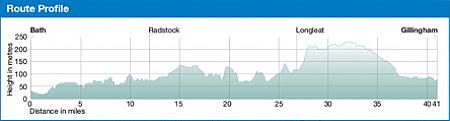
Sustrans kaarten geven een goed overzicht van het National Cycle Network. 25.000 km lang is het fietsnetwerk inmiddels. De routes zijn bewegwijzerd, autoluw en fietsvriendelijk. Oude spoorwegen zijn omgetoverd in fietspaden of er wordt gebruik gemaakt van jaagpaden langs waterwegen. De cartografie is duidelijk met veel praktische informatie. The official route map for the 85-mile (137km) ride from Bath to Bournemouth. This linear map shows the route and immediate surrounding area over a series of separate map panels. The full colour map based on Ordnance Survey data shows clearly mapped cycle routes on traffic-free paths, quiet lanes and roads, with easy to read contours, route profiles and mile markers. Also features detailed inset maps for the major towns and cities, tourist info and cycle shop and hire information, and other local routes. This is a ride that’s been popular with a great many local cyclists over the years and deserves a much wider audience. While the Paris-Nice might be a longer and more glamorous ride, the West Country’s very own ‘race to the sun’ offers an extremely pleasant meander through the West Country to the South Coast. Thankfully it avoids much of the higher ground of the surrounding chalky downland making this an enjoyable long-distance ride without taxing your climbing legs too much. The UNESCO World Heritage city of Bath provides the spectacular backdrop to this ride’s start. Your departure from the city is almost entirely traffic-free and takes in the Combe Down Tunnel which at just over a mile long, is the UK’s longest cycle and walking tunnel. Travelling through it for the first time is an incredible experience - enhanced further by the extraordinary audio-visual installations. You emerge blinking into a gently-rolling Somerset and eventually Wiltshire and Dorset landscape. Small towns such as Radstock, Frome, Gillingham and Blandford are passed through until you reach the busier conurbations of Poole and Bournemouth, where as in Bath, your passage is largely traffic-free. With its Victorian splendour, popular nightlife and seven miles of soft, golden sand Bournemouth attracts over five million visitors annually, and is where, hopefully, the sun will be waiting for you. Routes covered by this map: National Route 24 from Bath to Longleat National Route 25 from Longleat to Bournemouth
Schaal: 1:110.000
Engelstalig
EAN: 9781910845400
Uitgeverij: Sustrans (UK)
Serie: Sustrans National Cycle Network
Meest recente editie
Engelstalig


Op voorraad
Vóór 17 uur besteld, morgen in huis (Nederland)
- Vakkundige klantenservice
- Groot assortiment
- Gratis retourneren binnen 14 dagen
- Aangesloten bij WebwinkelKEUR
€ 13,50
Verder in deze serie

- Fietskaart Celtic Trail West Wales Cycle Map Sustrans
- Fietskaart Derby To York NN6B Cycle Map | Sustrans
- Fietskaart Lon Las Cymru South NN8A Cycle Map | Sustrans
- Fietskaart Noord-Ierland Ballyshannon to Ballycastle NN9C Cycle Map | Sustrans
- Fietskaart Noord-Ierland Belfast to Ballyshannon NN9B Cycle Map | Sustrans
- Fietskaart Noord-Ierland Loughshore Trail NN94 Cycle Map | Sustrans
- Fietskaart Noord-Ierland The North West Trail NN92 Cycle Map | Sustrans
- Fietskaart Noord-Ierland The Sperrins Region Cycle Map | Sustrans
- Fietskaart Oban to Campbeltown NN78 Cycle Map | Sustrans
- Fietskaart South Midlands NN6A Cycle Map | Sustrans
- Fietskaart West Midlands NN5B Cycle Map | Sustrans
Meer producten die interessant kunnen zijn
Wegenkaarten Zuid-Engeland


Wegenkaart - Landkaart Zuid-Engeland Wales - World Mapping Project (Reise Know-How)
Water- en scheurvaste wegenkaart
€ 11,25

Wandelgidsen Zuid-Engeland

Wandelgids 11 Dorset Pathfinder Guide
Pathfinder Guide 11 | Met Ordanance Survey kaarten
€ 17,99
Tijdelijk niet leverbaar
Wandelgids 67 Downs South NP & East Sussex Pathfinder Guide
Pathfinder Guide 67 | Met Ordanance Survey kaarten
€ 17,99

Wandelgids 27 Isle of Wight Pathfinder Guide (Short Walks)
Pathfinder Guide 27 | Met Ordanance Survey kaarten
€ 11,50
Reisgidsen Zuid-Engeland


Reisgids Zuid-Engeland - Londen Bath Oxford Cambridge De Groene Gids Michelin
€ 24,99
Tijdelijk niet leverbaar
Topografische kaarten Zuid-Engeland

Topografische Wandelkaart 182 Weston-super-Mare Bridgwater & Wells - Landranger Map
Wandelkaart & Fietskaart | Ordnance Survey (OS) Groot-Brittannië
€ 18,99

Topografische Wandelkaart OL15 van Groot-Brittannië (1:25.000) Purbeck / South Dorset - Explorer Map OL 15
Wandelkaart | Ordnance Survey (OS) Groot-Brittannië
€ 18,99
Topografische Wandelkaart 141 Cheddar Gorge / Mendip Hills West - Explorer Map
Wandelkaart & Fietskaart | Ordnance Survey (OS) Groot-Brittannië
€ 18,99
Tijdelijk niet leverbaar

Topografische Wandelkaart 155 Bristol / Bath - Explorer Map
Wandelkaart & Fietskaart | Ordnance Survey (OS) Groot-Brittannië
€ 18,99
Wandelkaarten Zuid-Engeland
Wandelkaart South Downs Way - National Trail Maps | Harvey Maps
Water- en scheurvaste wandelkaart
€ 25,99