- Gratis verzending vanaf 30 euro
- Levert in Nederland, België etc.
- Meer dan 30.000 titels
- Vakkundige klantenservice
- Snelle levering
- Veilig en eenvoudig betalen

Direct contact?
Bel +31 (0)6 42428571
maandag t/m vrijdag
van 10 tot 17 uur
Topografische Wandelkaart OL15 van Groot-Brittannië (1:25.000) Purbeck / South Dorset - Explorer Map OL 15
Wandelkaart | Ordnance Survey (OS) Groot-Brittannië
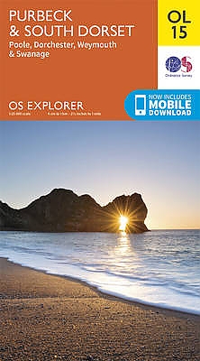
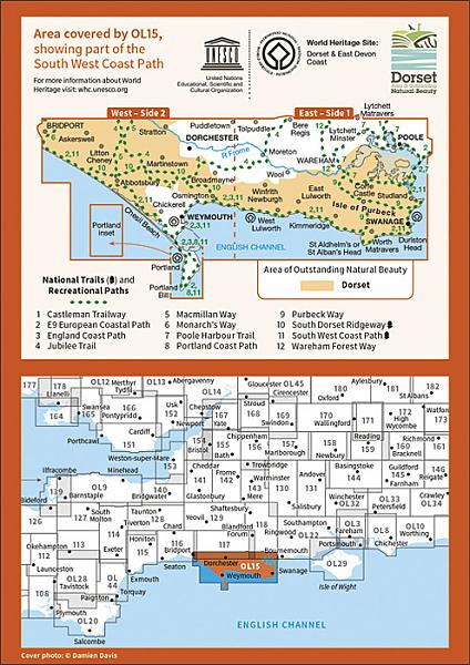
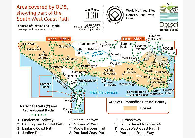
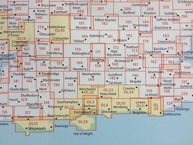
Deze gedetailleerde en informatieve topografische kaart (stafkaart, schaal 1:25.000) van Groot-Brittannië bevat alle topografische elementen van het landschap en geeft daarmee een nauwkeurig beeld van het terrein. Daarnaast heeft Ordnance Survey (OS) ook toeristische informatie op de meeste kaart verwerkt, zoals de aanduiding voor campings en ingetekende wandelpaden . Deze kaart is ideaal voor wandelaars of fietsers, maar ook voor de scouting of sportverenigingen die activiteiten in Groot-Brittannië gaan uitvoeren. De kaarten zijn voorzien van een GPS aanduiding en een duidelijke legenda. Sheet number OL15 in the OS Explorer map series is the ideal map for exploring the Purbeck coast and South Dorset. The Jurassic coast is a major draw for many outdoors enthusiasts and the beautiful countryside of South Dorset is perfect for walks and rides. With this map you will receive a code for use on your iOS or Android smartphone or tablet. Find our more at Mobile Download FAQ. Covering an expansive Area of Outstanding Natural Beauty, there"s a wealth of tranquil countryside and crashing coastline for you to explore. The peninsula of Purbeck is made up of 60 square miles of sculpted shores, steep cliffs and sandy beaches â ¬ a perfect location for all kinds of walking, from gentle ambling, to serious tramping. If you"re up to the challenge, why not cycle the 47-mile trail around Purbeck? Take the leisurely option with a week-long winding trip, or set off at a serious sprint, completing the course in one or two days. Find fossils and a medley of marine life at Kimmeridge Bay. The flats here provide the perfect platform for keen ecologists to explore the natural environment. Explore the woodlands and heath on Brownsea Island for the chance to spot red squirrels, Sika deer, kingfishers and oystercatchers. And if archaeology"s where your true interest lies, head to Dorchester to discover ancient sites, from the Maumbury Rings to Maiden Castle. Easy to follow, with clearly marked routes and rivers, we"ve left no stone unturned in preparing this essential aid to navigating Purbeck and South Dorset. Add it to your basket today and start mapping out your next trip. Highlights of the area include: Kimmeridge, Chesil Beach, Brownsea Island, Dorchester, Weymouth, River Frome, Swanage, and Wareham.
Schaal: 1:25.000
EAN: 9780319242544
Uitgeverij: Ordnance Survey (UK)
Serie: Explorer Map Zuid Engeland
Meest recente editie

Op voorraad
Levertijd 3 dagen (Nederland)
- Vakkundige klantenservice
- Groot assortiment
- Gratis retourneren binnen 14 dagen
- Aangesloten bij WebwinkelKEUR
€ 18,99
Verder in deze serie
- Topografische Wandelkaart 117 Cerne Abbas / Bere Regis - Explorer Map
- Topografische Wandelkaart 118 Shaftesbury / Cranborne Chase - Explorer Map
- Topografische Wandelkaart 129 Yeovil / Sherborne - Explorer Map
- Topografische Wandelkaart 130 Salisbury / Stonehenge - Explorer Map
- Topografische Wandelkaart 131 Romsey / Andover / Test Valley - Explorer Map
- Topografische Wandelkaart 141 Cheddar Gorge / Mendip Hills West - Explorer Map
- Topografische Wandelkaart 142 Shepton Mallet / Mendip Hills East - Explorer Map
- Topografische Wandelkaart 143 Warminster / Trowbridge - Explorer Map
- Topografische Wandelkaart 144 Basingstoke / Alton / Whitchurch - Explorer Map
- Topografische Wandelkaart 145 Guildford / Farnham - Explorer Map
- Topografische Wandelkaart 154 Bristol West / Portishead - Explorer Map
- Topografische Wandelkaart 155 Bristol / Bath - Explorer Map
- Topografische Wandelkaart 156 Chippenham / Bradford-on-Avon - Explorer Map
- Topografische Wandelkaart 157 Marlborough / Savernake Forest - Explorer Map
- Topografische Wandelkaart 158 Newbury / Hungerford - Explorer Map
- Topografische Wandelkaart 159 Reading Wokingham & Pangbourne - Explorer Map
- Topografische Wandelkaart 160 Windsor / Weybridge / Bracknell - Explorer Map
- Topografische Wandelkaart 167 Thornbury / Dursley / Yate - Explorer Map
- Topografische Wandelkaart 168 Stroud / Tetbury / Malmesbury - Explorer Map
- Topografische Wandelkaart 169 Cirencester / Swindon - Explorer Map
- Topografische Wandelkaart 170 Abingdon / Wantage / Vale of White Horse - Explorer Map
- Topografische Wandelkaart 171 Chiltern Hills West - Explorer Map
- Topografische Wandelkaart 172 Chiltern Hills East - Explorer Map
- Topografische Wandelkaart 179 Gloucester / Cheltenham / Stroud - Explorer Map
- Topografische Wandelkaart 180 Oxford - Explorer Map
- Topografische Wandelkaart 181 Chiltern Hills North - Explorer Map
- Topografische Wandelkaart OL3 van Groot-Brittannië (1:25.000) Meon Valley - Portsmouth Gosport & - Explorer Map OL 3
- Topografische Wandelkaart OL8 van Groot-Brittannië (1:25.000) Chichester, South Harting & Selsey - Explorer Map OL 8
- Topografische Wandelkaart OL10 van Groot-Brittannië (1:25.000) Arundel & Pulborough / Worthing & Bognor Regis Explorer Map OL 10
- Topografische Wandelkaart OL22 van Groot-Brittannië (1:25.000) New Forest - Explorer Map OL 22
- Topografische Wandelkaart OL29 van Groot-Brittannië (1:25.000) Isle of Wight - Explorer Map OL 29
- Topografische Wandelkaart OL32 van Groot-Brittannië (1:25.000) Winchester / New Alresford & East Meon - Explorer Map OL 32
- Topografische Wandelkaart OL33 van Groot-Brittannië (1:25.000) Haslemere & Petersfield / Midhurst & Selborn - Explorer Map OL 33
- Topografische Wandelkaart OL34 van Groot-Brittannië (1:25.000) Crawley & Horsham / Cranleigh & Billinghurst - Explorer Map OL 34
- Topografische Wandelkaart OL45 van Groot-Brittannië (1:25.000) The Cotswolds - Explorer Map OL 45
Meer producten die interessant kunnen zijn
Wegenkaarten Zuid-Engeland


Wegenkaart - Landkaart Zuid-Engeland Wales - World Mapping Project (Reise Know-How)
Water- en scheurvaste wegenkaart
€ 11,25

Wandelgidsen Zuid-Engeland

Wandelgids 11 Dorset Pathfinder Guide
Pathfinder Guide 11 | Met Ordanance Survey kaarten
€ 17,99
Tijdelijk niet leverbaar

Wandelgids 67 Downs South NP & East Sussex Pathfinder Guide
Pathfinder Guide 67 | Met Ordanance Survey kaarten
€ 17,99

Wandelgids 27 Isle of Wight Pathfinder Guide (Short Walks)
Pathfinder Guide 27 | Met Ordanance Survey kaarten
€ 11,50
Reisgidsen Zuid-Engeland


Reisgids Zuid-Engeland - Londen Bath Oxford Cambridge De Groene Gids Michelin
€ 24,99
Tijdelijk niet leverbaar
Wandelkaarten Zuid-Engeland
Wandelkaart South Downs Way - National Trail Maps | Harvey Maps
Water- en scheurvaste wandelkaart
€ 25,99
Fietskaarten Zuid-Engeland


Fietskaart 4 North and South Devon Cycle Maps UK | Cordee
Water- en scheurvaste fietskaart
Tijdelijk niet leverbaar