Wandelgids Walking in the Yorkshire Dales: South and West | Cicerone
Wharfedale, Littondale, Malhamdale, Dentdale and Ribblesdale
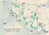
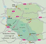
The Yorkshire Dales need little introduction: their picturesque scenery and hundreds of miles of footpaths, tracks and bridleways have been attracting walkers for decades. Part of a two-volume set, this guidebook presents over 40 routes in the south and west of the National Park, with bases including Sedburgh, Malham, Grassington, Skipton, Settle and Kirkby Lonsdale. The walks cover the valleys of Wharfedale, Littondale, Malhamdale, Ribblesdale and Dentdale – each with its own distinctive landscape and character. Also included is the Yorkshire Three Peaks, a 23 mile (37km) challenge to bag three iconic summits – Pen-y-ghent, Whernside and Ingleborough. Mostly circular and ranging from 3.5 to 13 miles (6–21km), the routes showcase Yorkshire's diverse landscapes, beautiful views and rich heritage and celebrate the 'ups, downs and endless in-betweens' of the Dales. With the exception of the Three Peaks walk, they are designed to suit most abilities: steeper sections are rare and usually short-lived. Detailed route description and 1:50,000 OS mapping are provided for each route, along with information on nearby points of interest and facilities. In addition, an introduction presents an overview of the region's plants and wildlife, geology and history and offers an insight into iconic local industries such as farming and quarrying. From bucolic pastureland to wild moors, the Dales have it all. Highlights include delightful riverside walking in Wharfedale, spectacular views of the distant Howgills and Lake District Fells, and the arresting limestone cliffs of Malham Cove. Charming villages and cosy pubs offer a warm welcome, but it is also possible to find tranquility and seclusion. The walks in this guide take in rolling hills, sweeping valleys and dancing streams, providing a wonderful introduction to this magnificent area.
Engelstalig
EAN: 9781852848859
Uitgeverij: Cicerone Press
Verschijningsdatum: 2017
Meest recente editie
Engelstalig
Op voorraad
Overmorgen in huis (Nederland)
- Vakkundige klantenservice
- Groot assortiment
- Gratis retourneren binnen 14 dagen
- Aangesloten bij WebwinkelKEUR
€ 16,99
Meer producten die interessant kunnen zijn
Wegenkaarten Noord-Engeland
Wegenkaart - Landkaart 502 Noord-Engeland - Michelin Regional
Northern England, the Midlands 502
€ 11,50
Wegenkaart - Landkaart Northern Engeland Noord-Engeland & the Midlands - World Mapping Project (Reise Know-How)
Water- en scheurvaste wegenkaart
€ 13,50
Wandelkaarten Noord-Engeland
Wandelkaartgids Hadrian's Wall Path
All the Ordnance Survey mapping needed for Hadrian's Wall Path
€ 13,50
Wandelkaart Hadrian's Wall Path - National Trail Maps | Harvey Maps
Water- en scheurvaste wandelkaart
€ 25,99
Wandelkaart Cleveland Way - National Trail Maps | Harvey Maps
Water- en scheurvaste wandelkaart
€ 25,99
Wandelkaart Coast to Coast - St. Bees to Robin Hood's Bay - National Trail Maps | Harvey Maps
Water- en scheurvaste wandelkaart
€ 25,99
Topografische kaarten Noord-Engeland
Topografische Wandelkaart OL27 van Groot-Brittannië (1:25.000) North York Moors Eastern area - Explorer Map OL 27
Wandelkaart | Ordnance Survey (OS) Groot-Brittannië
€ 18,99
Topografische Wandelkaart 278 Sheffield / Barnsley Rotherham - Explorer Map
Wandelkaart & Fietskaart | Ordnance Survey (OS) Groot-Brittannië
€ 18,99
Tijdelijk niet leverbaar
Topografische Wandelkaart 290 York / Selby / Tadcaster - Explorer Map
Wandelkaart & Fietskaart | Ordnance Survey (OS) Groot-Brittannië
€ 18,99
Tijdelijk niet leverbaar
Topografische Wandelkaart 80 Cheviot Hills & Kielder Water - Landranger Map
Wandelkaart & Fietskaart | Ordnance Survey (OS) Groot-Brittannië
€ 18,99
Reisgidsen Noord-Engeland
Reisgids Slow North York Moors & Yorkshire Wolds Bradt Travel Guide
Moors, Dales And Coast, Including Yorklocal, Characterful Guides
€ 21,90


