- Gratis verzending vanaf 30 euro
- Levert in Nederland, België etc.
- Meer dan 30.000 titels
- Vakkundige klantenservice
- Snelle levering
- Veilig en eenvoudig betalen

Direct contact?
Bel +31 (0)6 42428571
maandag t/m vrijdag
van 10 tot 17 uur
Wandelgids Coast to Coast Walk Cicerone Guidebooks
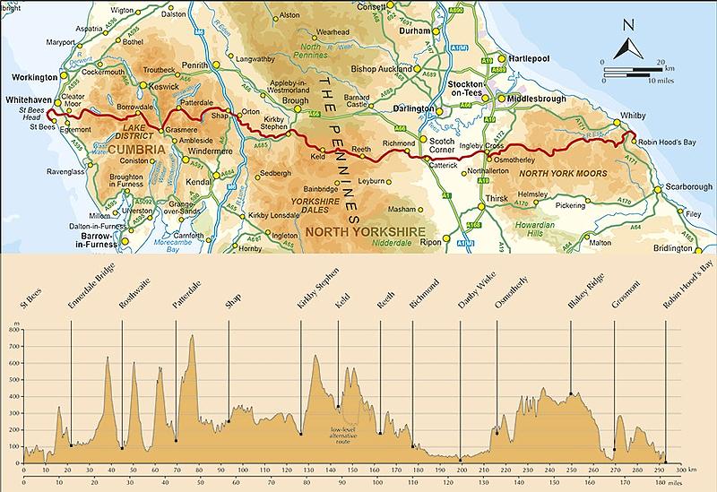
From St Bees Head in Cumbria to Robin Hood’s Bay on Yorkshire’s
First devised by Alfred Wainwright, the Coast to Coast Walk has emerged as a favourite among long-distance walkers. The route stretches some 185 miles (296km) from St Bees, an historic seaside village on Cumbria's west coast to Robin Hood's Bay in North Yorkshire. It is suitable for most fit walkers and can be comfortably walked in around a fortnight. This guidebook presents the full route from west to east in 13 stages of 10 ½-20 ¾ miles (16.8-33.2km), with summaries covering the opposite direction. Alongside step-by-step route description, 1:100,000 mapping and fascinating notes about points of interest along the way, a comprehensive trek planner offers a helpful overview of facilities on route, and full accommodation listings and useful contacts can be found in the appendices. There is also a wealth of background information covering geology, history, wildlife and plants, and a list of further reading. In addition, the guide INCLUDES a pocket-sized map booklet containing all the OS 1:25,000 mapping needed to complete the route, saving the need to carry numerous bulky maps. The Coast to Coast Walk crosses three national parks – the Lake District, the Yorkshire Dales and the North York Moors – and is characterised by fantastic scenery, varied landscapes and great camaraderie among walkers. This guide is an ideal companion to discovering this captivating route, which was named by Country Walking magazine as the second best walk in the world!
Engelstalig
EAN: 9781852847593
Auteur(s): Terry marsh
Uitgeverij: Cicerone Press
Verschijningsdatum: 2017
Meest recente editie
Engelstalig
256 pagina's

Op voorraad
Vóór 17 uur besteld, morgen in huis (Nederland)
- Vakkundige klantenservice
- Groot assortiment
- Gratis retourneren binnen 14 dagen
- Aangesloten bij WebwinkelKEUR
€ 22,99
Meer producten die interessant kunnen zijn
Wegenkaarten Noord-Engeland


Wegenkaart - Landkaart 502 Noord-Engeland - Michelin Regional
Northern England, the Midlands 502
€ 11,50


Wegenkaart - Landkaart Northern Engeland Noord-Engeland & the Midlands - World Mapping Project (Reise Know-How)
Water- en scheurvaste wegenkaart
€ 13,50
Wandelkaarten Noord-Engeland

Wandelkaartgids Hadrian's Wall Path
All the Ordnance Survey mapping needed for Hadrian's Wall Path
€ 13,50

Wandelkaart Hadrian's Wall Path - National Trail Maps | Harvey Maps
Water- en scheurvaste wandelkaart
€ 25,99

Wandelkaart Cleveland Way - National Trail Maps | Harvey Maps
Water- en scheurvaste wandelkaart
€ 25,99

Wandelkaart Coast to Coast - St. Bees to Robin Hood's Bay - National Trail Maps | Harvey Maps
Water- en scheurvaste wandelkaart
€ 25,99
Topografische kaarten Noord-Engeland

Topografische Wandelkaart OL27 van Groot-Brittannië (1:25.000) North York Moors Eastern area - Explorer Map OL 27
Wandelkaart | Ordnance Survey (OS) Groot-Brittannië
€ 18,99

Topografische Wandelkaart 278 Sheffield / Barnsley Rotherham - Explorer Map
Wandelkaart & Fietskaart | Ordnance Survey (OS) Groot-Brittannië
€ 18,99
Tijdelijk niet leverbaar

Topografische Wandelkaart 290 York / Selby / Tadcaster - Explorer Map
Wandelkaart & Fietskaart | Ordnance Survey (OS) Groot-Brittannië
€ 18,99
Tijdelijk niet leverbaar

Topografische Wandelkaart 80 Cheviot Hills & Kielder Water - Landranger Map
Wandelkaart & Fietskaart | Ordnance Survey (OS) Groot-Brittannië
€ 18,99
Reisgidsen Noord-Engeland


Reisgids Slow North York Moors & Yorkshire Wolds Bradt Travel Guide
Moors, Dales And Coast, Including Yorklocal, Characterful Guides
€ 21,90

