- Gratis verzending vanaf 30 euro
- Levert in Nederland, België etc.
- Meer dan 30.000 titels
- Vakkundige klantenservice
- Snelle levering
- Veilig en eenvoudig betalen

Direct contact?
Bel +31 (0)6 42428571
maandag t/m vrijdag
van 10 tot 17 uur
Wandelgids The Ribble Way Cicerone Guidebooks
A one-week walk across Lancashire into Yorkshire from Preston to the source

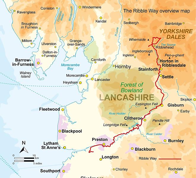
The 72 mile (116km) Ribble Way is described in seven stages, ranging from 8.25 to 17 miles (13.3 to 27.4km). The route follows the Ribble valley, from the estuary mouth near Preston to the river's source on Cam Fell in the Yorkshire Dales. The route might not be the most challenging of Long Distance routes, but the contrast through a succession of different landscapes can be immensely satisfying for novice and experienced walkers alike.
The guide provides detailed route descriptions, OS mapping and a route summary table, with variants included for day walkers. Information is included on points of interest along the route, plus there's also background information on the landscape, wildlife, and history, and planning details on when to go, where to stay and what to take. The River Ribble springs from the limestone of the Yorkshire Dales, high on Cam Fell in the heart of Three Peak country.
Initially forcing a passage between high, rugged moorland hills, it then breaks free to wind through gentler countryside south of Settle, meandering lazily through alternating pasture and ancient woodland, where old manor houses and early 18th-century village cottages still hold sway against the pervasive tide of modernity. Beyond Preston, the river dramatically changes yet again, trained to run straight to the Irish Sea, but further to the west, a vast expanse of the salt marsh still remains and attracts huge populations of birds, particularly in winter.
Engelstalig
EAN: 9781786310910
Auteur(s): Kelsall, d.
Uitgeverij: Cicerone Press
Verschijningsdatum: 2023
Meest recente editie
Engelstalig
112 pagina's

Op voorraad
Overmorgen in huis (Nederland)
- Vakkundige klantenservice
- Groot assortiment
- Gratis retourneren binnen 14 dagen
- Aangesloten bij WebwinkelKEUR
€ 22,99
Meer producten die interessant kunnen zijn
Wegenkaarten Noord-Engeland


Wegenkaart - Landkaart 502 Noord-Engeland - Michelin Regional
Northern England, the Midlands 502
€ 11,50


Wegenkaart - Landkaart Northern Engeland Noord-Engeland & the Midlands - World Mapping Project (Reise Know-How)
Water- en scheurvaste wegenkaart
€ 13,50
Wandelkaarten Noord-Engeland

Wandelkaartgids Hadrian's Wall Path
All the Ordnance Survey mapping needed for Hadrian's Wall Path
€ 13,50

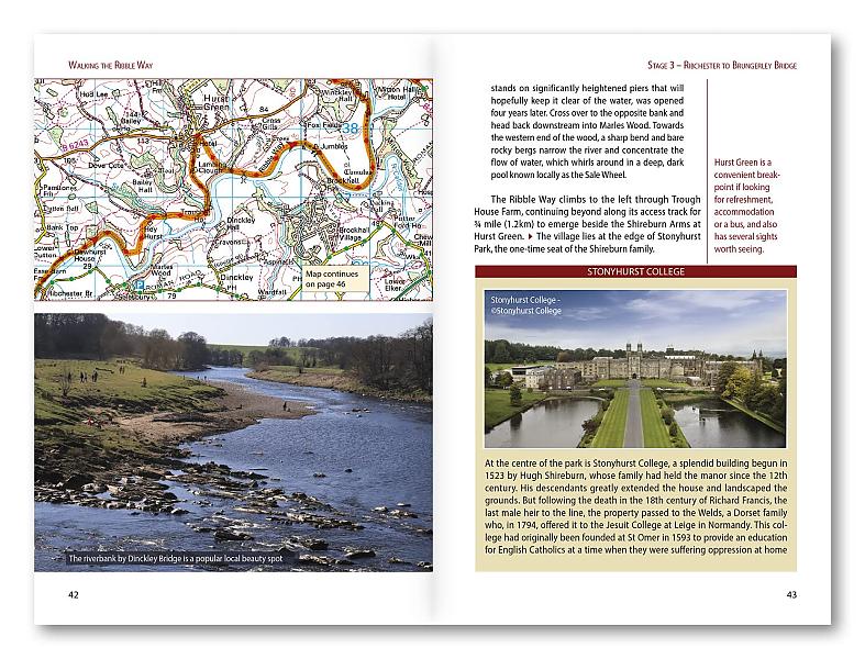
Wandelkaart Hadrian's Wall Path - National Trail Maps | Harvey Maps
Water- en scheurvaste wandelkaart
€ 25,99

Wandelkaart Cleveland Way - National Trail Maps | Harvey Maps
Water- en scheurvaste wandelkaart
€ 25,99

Wandelkaart Coast to Coast - St. Bees to Robin Hood's Bay - National Trail Maps | Harvey Maps
Water- en scheurvaste wandelkaart
€ 25,99
Topografische kaarten Noord-Engeland

Topografische Wandelkaart OL27 van Groot-Brittannië (1:25.000) North York Moors Eastern area - Explorer Map OL 27
Wandelkaart | Ordnance Survey (OS) Groot-Brittannië
€ 18,99

Topografische Wandelkaart 278 Sheffield / Barnsley Rotherham - Explorer Map
Wandelkaart & Fietskaart | Ordnance Survey (OS) Groot-Brittannië
€ 18,99
Tijdelijk niet leverbaar

Topografische Wandelkaart 290 York / Selby / Tadcaster - Explorer Map
Wandelkaart & Fietskaart | Ordnance Survey (OS) Groot-Brittannië
€ 18,99
Tijdelijk niet leverbaar

Topografische Wandelkaart 80 Cheviot Hills & Kielder Water - Landranger Map
Wandelkaart & Fietskaart | Ordnance Survey (OS) Groot-Brittannië
€ 18,99
Reisgidsen Noord-Engeland


Reisgids Slow North York Moors & Yorkshire Wolds Bradt Travel Guide
Moors, Dales And Coast, Including Yorklocal, Characterful Guides
€ 21,90

