- Gratis verzending vanaf 30 euro
- Levert in Nederland, België etc.
- Meer dan 30.000 titels
- Vakkundige klantenservice
- Snelle levering
- Veilig en eenvoudig betalen

Direct contact?
Bel +31 (0)6 42428571
maandag t/m vrijdag
van 10 tot 17 uur
Wandelkaart Dartmoor North Noord - Walking Maps Superwalker | Harvey Maps
Water- en scheurvaste wandelkaart

De Harvey Map is de wandelkaart voor het wandelen in de mooiste natuurgebieden in het Groot-Brittannië. Duidelijke topografische wandelkaarten met praktische informatie van de route zoals overnachtingsmogelijkheden, eetgelegenheden en bezienswaardigheden. Deze wandelkaart is scheur- en watervast. Met GPS compatible (UTM-Grid). Dartmoor's famous Tors including Haytor Rocks and Yes Tor. The format gives more mapping on the sheet without making the map heavy and bulky. The fold has been developed to allow you to open directly to any part, and either side of the sheet easily no more struggling in the wind. The clarity of the mapping has been improved to enable more people to read it without their glasses. The map is uncluttered by information irrelevant to the walker. The precise contouring and delicate hill shading give an immediate picture of the ground. Less than half the weight of a laminated map. GPS compatible. Experience the satisfaction of fine navigation with the Superwalker XT25 now printed on our 100% waterproof and almost indestructible paper, whatever the weather!
Schaal: 1:25.000
Engelstalig


Op voorraad
Levertijd 3 dagen (Nederland)
- Vakkundige klantenservice
- Groot assortiment
- Gratis retourneren binnen 14 dagen
- Aangesloten bij WebwinkelKEUR
€ 25,99
Meer producten die interessant kunnen zijn
Wandelgidsen Devon / Cornwall
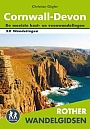
Wandelgids Cornwall Devon Rother Wandelgids
50 Wandelingen | De mooiste kust- en veenwandelingen
€ 18,99
Wandelgids The South West Coast Path (Zoutpad) Cicerone Guidebooks
From Minehead to South Haven Point
€ 21,99

Wandelgids Cornwall Coast Path (Zoutpad) Part 2 Bude to Falmouth Trailblazer
€ 19,90
Tijdelijk niet leverbaar
Reisgidsen Devon / Cornwall


Reisgids Slow Devon South & Dartmoor Bradt Travel Guide
Local, Characterful Guides To Britain's Special Places
€ 16,99
Tijdelijk niet leverbaar
Topografische kaarten Devon / Cornwall
Topografische Wandelkaart 102 Land's End - Explorer Map
Wandelkaart & Fietskaart | Ordnance Survey (OS) Groot-Brittannië
€ 18,99
Topografische Wandelkaart OL28 van Groot-Brittannië (1:25.000) Dartmoor - Explorer Map OL 28
Wandelkaart | Ordnance Survey (OS) Groot-Brittannië
€ 18,99
Topografische Wandelkaart 204 Truro / Falmouth Roseland Peninsula - Landranger Map
Wandelkaart & Fietskaart | Ordnance Survey (OS) Groot-Brittannië
€ 18,99
Topografische Wandelkaart 203 Land's End / Isles of Scilly St Ives & Lizard Point - Landranger Map
Wandelkaart & Fietskaart | Ordnance Survey (OS) Groot-Brittannië
€ 18,99