Wegenkaart - landkaart 7 Roadmap South West England & South Wales | Ordnance Survey
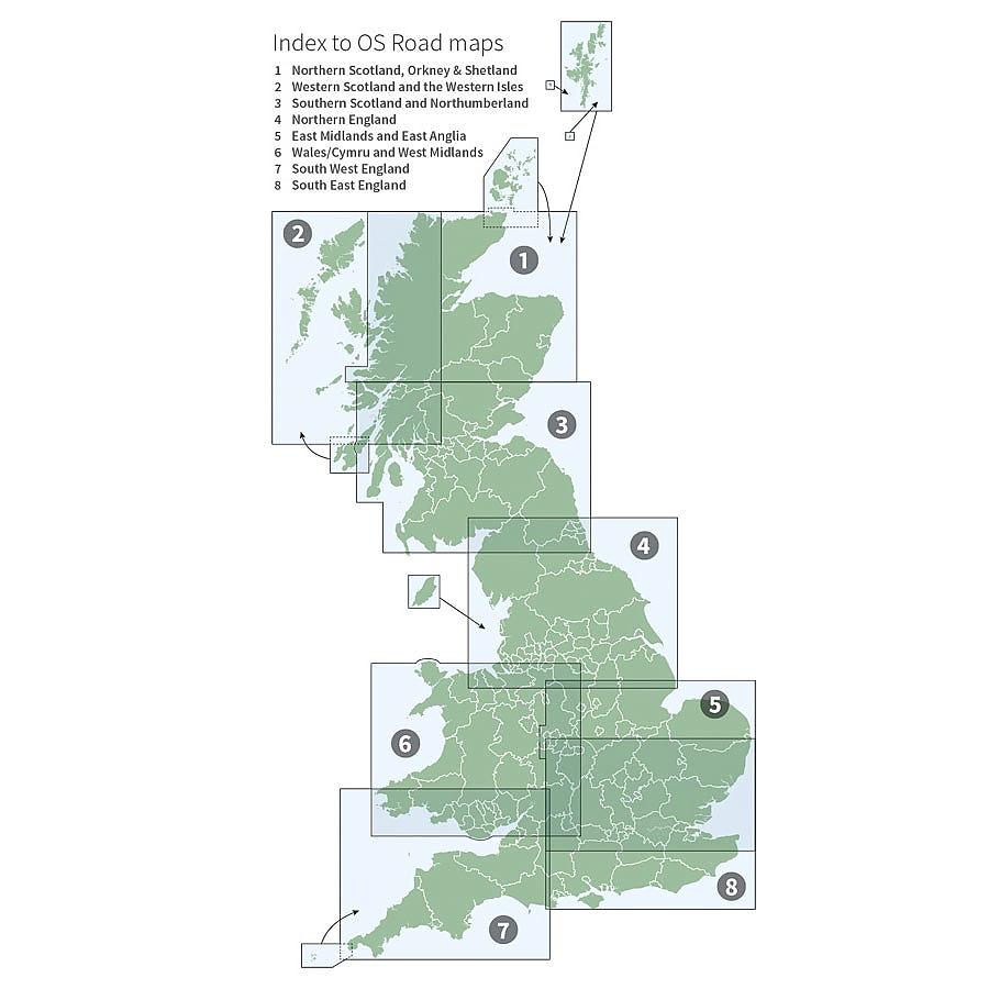
Schitterende wegenkaart van Ordnance Survey, de Britse topografische dienst. De kaart staat boordevol praktische informatie, aangeduid met pictogrammen. Campings, ook de kleinere, jeugdherbergen, veerdiensten, vuurtorens, musea, natuurreservaten staan duidelijk vermeld. Het wegniveau overzichtelijk, wegnummers zijn aangegeven. The OS Roadmaps series are single sided folded maps, the 8 maps provide GB 1: 250 000 coverage to enable the end user to navigate and plan their road journey. The maps include all motorways, primary routes and A roads plus detailed tourist information including National Parks, Country Parks and World Heritage sites and a useful town and city gazetteer. The eight maps in the series are Northern Scotland, Orkney & Shetland, Western Scotland and the Western Isles, Southern Scotland and Northumberland, Northern England, East Midlands and East Anglia, Wales/Cymru and West Midlands, South West England and South East England.
Schaal: 1:250.000
EAN: 9780319263792
Uitgeverij: Ordnance Survey (UK)
Serie: Ordnance Survey Road Maps
Meest recente editie
Op voorraad
Vóór 17 uur besteld, morgen in huis (Nederland)
- Vakkundige klantenservice
- Groot assortiment
- Gratis retourneren binnen 14 dagen
- Aangesloten bij WebwinkelKEUR
€ 11,99
Verder in deze serie
Meer producten die interessant kunnen zijn
Wandelgidsen Devon / Cornwall
Wandelgids Cornwall Devon Rother Wandelgids
50 Wandelingen | De mooiste kust- en veenwandelingen
€ 18,99
Tijdelijk niet leverbaar
Wandelgids The South West Coast Path (Zoutpad) Cicerone Guidebooks
From Minehead to South Haven Point
€ 21,99
Reisgidsen Devon / Cornwall
Reisgids Slow Devon South & Dartmoor Bradt Travel Guide
Local, Characterful Guides To Britain's Special Places
€ 16,99
Tijdelijk niet leverbaar
Topografische kaarten Devon / Cornwall
Topografische Wandelkaart 102 Land's End - Explorer Map
Wandelkaart & Fietskaart | Ordnance Survey (OS) Groot-Brittannië
€ 18,99
Topografische Wandelkaart OL28 van Groot-Brittannië (1:25.000) Dartmoor - Explorer Map OL 28
Wandelkaart | Ordnance Survey (OS) Groot-Brittannië
€ 18,99
Topografische Wandelkaart 204 Truro / Falmouth Roseland Peninsula - Landranger Map
Wandelkaart & Fietskaart | Ordnance Survey (OS) Groot-Brittannië
€ 18,99
Topografische Wandelkaart 203 Land's End / Isles of Scilly St Ives & Lizard Point - Landranger Map
Wandelkaart & Fietskaart | Ordnance Survey (OS) Groot-Brittannië
€ 18,99
Wandelkaarten Devon / Cornwall
Wandelkaart South West Coast Path 1 Minehead to St Ives - National Trail Maps (Zoutpad) | Harvey Maps
Water- en scheurvaste wandelkaart
€ 25,99
Wandelkaart South West Coast Path 3 Plymouth to Poole Harbour - National Trail Maps (Zoutpad) | Harvey Maps
Water- en scheurvaste wandelkaart
€ 25,99
Wandelkaart South West Coast Path 2 St Ives - Plymouth - National Trail Maps (Zoutpad) | Harvey Maps
Water- en scheurvaste wandelkaart
€ 25,99
Tijdelijk niet leverbaar


