- Gratis verzending vanaf 30 euro
- Levert in Nederland, België etc.
- Meer dan 30.000 titels
- Vakkundige klantenservice
- Snelle levering
- Veilig en eenvoudig betalen

Direct contact?
Bel +31 (0)6 42428571
maandag t/m vrijdag
van 10 tot 17 uur
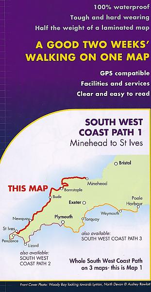
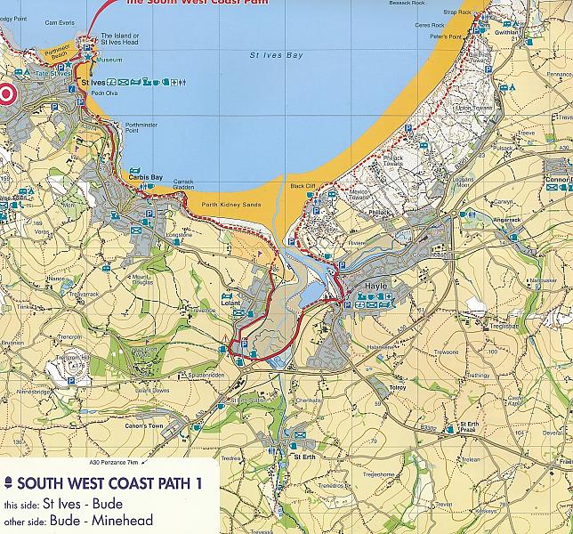
Wandelkaart South West Coast Path 1 Minehead to St Ives - National Trail Maps (Zoutpad) | Harvey Maps
Water- en scheurvaste wandelkaart
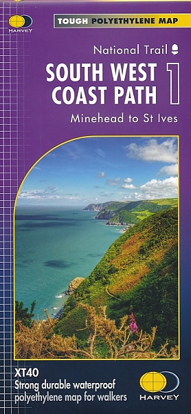
De Harvey Map is de wandelkaart voor het lange afstand wandelpad in het Groot-Brittannië. Duidelijke topografische wandelkaarten met praktische informatie van de route zoals overnachtingsmogelijkheden, eetgelegenheden en bezienswaardigheden. Deze wandelkaart is scheur- en watervast. Met GPS compatible (UTM-Grid). Ideal map for walkers on Britiain's longest and one of its most popular National Trails. It runs along the coast of Somerset, Cornwall, Devon, and Dorset from Minehead round via Land's End to Poole. It includes all 95 miles of the World Heritage site known as the Jurassic Coast.
6 HARVEY maps will cover the whole 630-mile route. Each map covers a section of the Path suitable for 8-9 days of walking.
Map 1 covers the Path from the start at Minehead to Bude
Schaal: 1:40.000
Engelstalig
Op voorraad
Levertijd 4 dagen (Nederland)
- Vakkundige klantenservice
- Groot assortiment
- Gratis retourneren binnen 14 dagen
- Aangesloten bij WebwinkelKEUR
€ 25,99
Meer producten die interessant kunnen zijn
Wandelgidsen Devon / Cornwall
Wandelgids Cornwall Devon Rother Wandelgids
50 Wandelingen | De mooiste kust- en veenwandelingen
€ 18,99
Wandelgids The South West Coast Path (Zoutpad) Cicerone Guidebooks
From Minehead to South Haven Point
€ 21,99


Wandelgids Cornwall Coast Path (Zoutpad) Part 2 Bude to Falmouth Trailblazer
€ 19,90
Tijdelijk niet leverbaar
Reisgidsen Devon / Cornwall


Reisgids Slow Devon South & Dartmoor Bradt Travel Guide
Local, Characterful Guides To Britain's Special Places
€ 16,99
Tijdelijk niet leverbaar
Topografische kaarten Devon / Cornwall
Topografische Wandelkaart OL28 van Groot-Brittannië (1:25.000) Dartmoor - Explorer Map OL 28
Wandelkaart | Ordnance Survey (OS) Groot-Brittannië
€ 18,99
Topografische Wandelkaart 102 Land's End - Explorer Map
Wandelkaart & Fietskaart | Ordnance Survey (OS) Groot-Brittannië
€ 18,99
Topografische Wandelkaart 204 Truro / Falmouth Roseland Peninsula - Landranger Map
Wandelkaart & Fietskaart | Ordnance Survey (OS) Groot-Brittannië
€ 18,99
Topografische Wandelkaart 203 Land's End / Isles of Scilly St Ives & Lizard Point - Landranger Map
Wandelkaart & Fietskaart | Ordnance Survey (OS) Groot-Brittannië
€ 18,99