- Gratis verzending vanaf 30 euro
- Levert in Nederland, België etc.
- Meer dan 30.000 titels
- Vakkundige klantenservice
- Snelle levering
- Veilig en eenvoudig betalen

Direct contact?
Bel +31 (0)6 42428571
maandag t/m vrijdag
van 10 tot 17 uur
Wandelkaart Mourne Mountains - Walking Maps Superwalker | Harvey Maps
Water- en scheurvaste wandelkaart
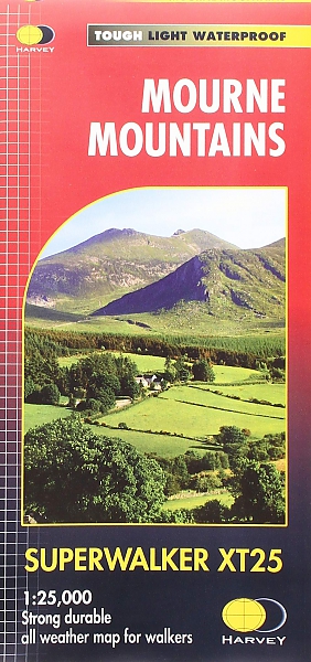
De Harvey Map is de wandelkaart voor het lange afstand wandelpad in het Groot-Brittannië. Duidelijke topografische wandelkaarten met praktische informatie van de route zoals overnachtingsmogelijkheden, eetgelegenheden en bezienswaardigheden. Deze wandelkaart is scheur- en watervast. Met GPS compatible (UTM-Grid). Mourne Mountains: The Mourne Mountains, also called the Mournes or Mountains of Mourne are a granite mountain range in County Down in the south east of Northern Ireland. They include the highest mountains in Northern Ireland and the province of Ulster. The highest of these is Slieve Donard at 850 metres (2790ft). The Mournes is an Area of Outstanding Natural Beauty and has been proposed as the first national park in Northern Ireland. The area is partly owned by the National Trust and sees a large number of visitors every year. The Mourne Wall is among the more famous features in the Mournes. It is a 35km (22mls) drystone wall that crosses fifteen summits, constructed to define the boundaries of land purchased by the Belfast Water Commissioners in the late 1800s. Also included in this map is The Mourne Way Long Distance Footpath.
Schaal: 1:25.000
Engelstalig


EAN: 9781851376124
Uitgeverij: Harvey Maps (UK)
Engelstalig
direct leverbaar
25,99
Meer producten die interessant kunnen zijn
Koopjes Noord-Ierland
Fietskaart Noord-Ierland Belfast to Ballyshannon NN9B Cycle Map | Sustrans
van 10.99 voor 3.99!
€ 3,99
Wandelgidsen Noord-Ierland
Topografische kaarten Noord-Ierland
Topografische Wandelkaart Noord-Ierland 26 Lough Allen Discovery Map Northern Ireland
Wandelkaart & Fietskaart | Ordnance Survey (OS) Ireland
€ 18,99