- Gratis verzending vanaf 30 euro
- Levert in Nederland, België etc.
- Meer dan 30.000 titels
- Vakkundige klantenservice
- Snelle levering
- Veilig en eenvoudig betalen

Direct contact?
Bel +31 (0)6 42428571
maandag t/m vrijdag
van 10 tot 17 uur
Wandelgids Trekking in the Vosges and Jura GR5 Trail GR 53 Cicerone Guidebooks
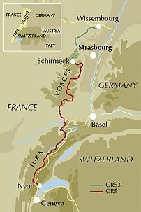
Schirmeck to Lac Léman, and the GR53
This guidebook describes a long-distance walking route through the delightful Vosges and Jura. Situated in France near the eastern border, the three regional parks of the Ballons des Vosges, Northern Vosges and Jura Mountains boast verdant forests, striking rock features and low rounded summits offering spectacular views. Yet, in spite of their extensive network of well-maintained paths, they are not high profile tourist destinations. This walk offers a chance to uncover the hidden secrets of this fascinating area, from its rich wildlife to ancient ruins. Starting in Wissembourg at the northeastern tip of France, the route follows the GR53 southwest to Schirmeck, before picking up the central section of the much-celebrated GR5 (which runs from the Hook of Holland to Nice) between Schirmeck and Nyon on Lake Geneva. The scenery is as varied as it is beautiful, from the tranquil forests of the Northern Vosges to the impressive river gorges of the Jura, from long-forgotten castles to the charming half-timbered villages of old Alsace. Well within the capabilities of any moderately fit walker and clearly waymarked, the entire trek takes five to six weeks, although it could also be walked in stages. The guide presents the route in 11 chapters, which in turn are broken into short sections of a few hours each, allowing for a flexible itinerary and easy route planning. There are also suggestions for shorter circular routes making use of sections of the GR53/GR5, as well as an overview of other long-distance routes in the region. A summary of local history, plants and wildlife and delicacies can be found in the introduction and appendices offer details of facilities on route and full accommodation listings. With clear route description and a wealth of information to help plan your trip, this comprehensive guide is an ideal companion to discovering this interesting and varied route.
Engelstalig
EAN: 9781852848125
Auteur(s): Smith, l.
Uitgeverij: Cicerone Press
Verschijningsdatum: 2017
Meest recente editie
Engelstalig
206 pagina's
Op voorraad
Vóór 17 uur op werkdagen besteld, morgen in huis (Nederland)
- Vakkundige klantenservice
- Groot assortiment
- Gratis retourneren binnen 14 dagen
- Aangesloten bij WebwinkelKEUR
€ 22,90
Meer producten die interessant kunnen zijn
Wandelkaarten Vogezen / Elzas-Lotharingen
Wandelkaart 2222 Vogezen Zuid Elzas / Vogezen Colmar, Mülhausen, Mulhouse 2-delige kaart Kompass
Water- en scheurvaste wandelkaart
€ 14,99
Wandelkaart Fietskaart 28 Vogezen Zuid Vosges du Sud - Ballon d'Alsace - Le Hohneck Top 75 | IGN
Institut Geographique National (IGN)
€ 11,99
Topografische kaarten Vogezen / Elzas-Lotharingen
Topografische Wandelkaart van Frankrijk 3719OT - Colmar Le Hohneck Grand-Ballon / Munster Guebwiller
Carte de Randonnee | Wandelkaart | Institut Geographique National (IGN) Frankrijk
€ 16,50
Topografische Wandelkaart van Frankrijk 3618OT - Le Hohneck / Gerardmer / La Bresse Col de la Schlucht
Carte de Randonnee | Wandelkaart | Institut Geographique National (IGN) Frankrijk
€ 16,50
Topografische Wandelkaart van Frankrijk 3718OT - Selestat Col du Bonhomme Riquewihr Kaysersberg
Carte de Randonnee | Wandelkaart | Institut Geographique National (IGN) Frankrijk
€ 16,50
Topografische Wandelkaart van Frankrijk 3520ET - Ballon d'Alsace PNR Giromagny -Kruth
Carte de Randonnee | Wandelkaart | Institut Geographique National (IGN) Frankrijk
€ 16,50
Wegenkaarten Vogezen / Elzas-Lotharingen

Fietsgidsen Vogezen / Elzas-Lotharingen

Fietsgids Radatlas Elsass Bikeline Esterbauer
Bike Line Gids: Pfälzerwald, Jura, dem Rhein und Lothringen
€ 16,90


Fietsgids Mosel-Radweg Frankreich Frankrijk Moselle Bikeline Esterbauer
Von der Quelle zum Dreiländereck, 286 km van bron tot Luxemburg
€ 14,99
Fietskaarten Vogezen / Elzas-Lotharingen

Fietskaart 121 Nancy Epinal Vallee de la Moselle - IGN Top 100 - Tourisme et Velo
Water- en scheurvaste fietskaart
€ 10,50
Fietskaart 130 Vesoul Langres Vallee de la Saone - IGN Top 100 - Tourisme et Velo
Water- en scheurvaste fietskaart
€ 10,50

Fietskaart 122 Colmar Mulhouse / Basel PNR des Ballons des Vosges Alsace du Sud (Sundgau) - IGN Top 100 - Tourisme et Velo
Water- en scheurvaste fietskaart
€ 10,50
Fietskaart 120 Saint-Dizier Chaumont PNR de la Foret d'Orient - IGN Top 100 - Tourisme et Velo
Water- en scheurvaste fietskaart
€ 10,50
Reisgidsen Vogezen / Elzas-Lotharingen

Reisgids Metz und Nancy mit Bar-le-Duc CityTrip | Reise Know-How
Tijdelijk niet leverbaar
Wandelgidsen Vogezen / Elzas-Lotharingen

Wandelgids 276 Elsass Rother Wanderführer | Rother Bergverlag
50 Wandelingen | Oberrhein Elsässer Weinstrasse Sundgau
€ 16,90