- Gratis verzending vanaf 30 euro
- Levert in Nederland, België etc.
- Meer dan 30.000 titels
- Vakkundige klantenservice
- Snelle levering
- Veilig en eenvoudig betalen

Direct contact?
Bel +31 (0)6 42428571
maandag t/m vrijdag
van 10 tot 17 uur
Wandelgids The Ceredigion and Snowdonia Coast Paths | Cicerone
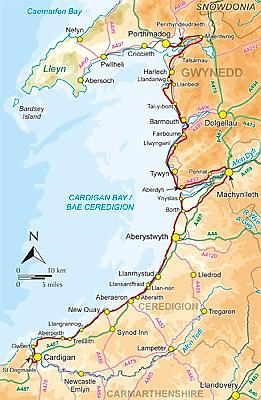
the Ceredigion Coast Path and Snowdonia Coast Path

As part of the Wales Coast Path, the Ceredigion Coast Path and Snowdonia Coast Path trace a curve of 233km (145 miles) of coastal and inland walking down Cardigan Bay. This guidebook describes a 16-stage guide to the walk from Porthmadog to St Dogmaels covering the trail between the Llyn Peninsula and the Pembrokeshire Coast Path. .In 16 day stages from Porthmadog to St Dogmaels, this guidebook offers all the information walkers need to complete the 233km (145 miles) section of the Wales Coast Path that curve down Cardigan Bay, passing through a range of contrasting landscapes. Six days are spent on the Snowdonia Coast Path, two around the Dyfi Estuary, seven on the Ceredigion Coast Path and one from Cardigan to St Dogmaels. Linking the Llyn Peninsula Coast Path with that of the Pembrokeshire Coastal Path, this section takes in Snowdonia National Park"s splendid coastal plains, leads inland through beautiful hill country around the Dyfi Estuary and follows some of the finest coastline in all of Wales on the Ceredigion Coast Path. The Snowdonia Coast Path This is not an official title, but since most of the route is within Snowdonia National Park it seems appropriate. The truly coastal sections tend to be along huge sandy beaches, while the remainder is through nearby hill country or across the coastal plains. The Ceredigion Coast Path The path starts at the flat lands at Ynyslas and joins the Wales Coast Path at Borth. Over a distance of just short of 100km (60 miles), it links Ynyslas with Cardigan on the Teifi Estuary, following some of Wales' finest and most varied coast. Stong walkers could complete the full walk in just less than two weeks. It is also worth considering building in rest days in order to visit , say Harlech Castle, or ride on of the narrow gauge railways. With excellent public transport links, you don't have to tackle it all at once. It's easy to split into short breaks and day walks as suits your schedule. background information on geology, history and the many points of interest along the way illustrated by OS 1:50,000 map extracts and custom-drawn sketch maps practical details on facilities, accommodation and travel
EAN: 9781852847388
Uitgeverij: Cicerone Press
Verschijningsdatum: 2014
Meest recente editie

(Tijdelijk) niet leverbaar
- Vakkundige klantenservice
- Groot assortiment
- Gratis retourneren binnen 14 dagen
- Aangesloten bij WebwinkelKEUR
Meer producten die interessant kunnen zijn
Wegenkaarten Wales
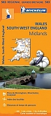
Wegenkaart - Landkaart 503 Wales & The Midlands - Michelin Regional
Wales, the Midlands, South West England 503
€ 11,50

Reisgidsen Wales


Reisgids Engeland Noord & Wales Trotter
De no-nonsensegids voor een allesomvattende trip.
€ 18,99
Tijdelijk niet leverbaar


Topografische kaarten Wales

Topografische Wandelkaart 152 Newport / Pontypool - Explorer Map
Wandelkaart & Fietskaart | Ordnance Survey (OS) Groot-Brittannië
€ 18,99

Topografische Wandelkaart 189 Hereford & Ross-on-Wye - Explorer Map
Wandelkaart & Fietskaart | Ordnance Survey (OS) Groot-Brittannië
€ 18,99
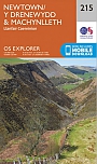
Topografische Wandelkaart 215 Newtown / Machynlleth Llanfair Caereinion - Explorer Map
Wandelkaart & Fietskaart | Ordnance Survey (OS) Groot-Brittannië
€ 18,99
Topografische Wandelkaart 262 Anglesey West Holyhead - Explorer Map
Wandelkaart & Fietskaart | Ordnance Survey (OS) Groot-Brittannië
€ 18,99
Fietskaarten Wales
Wandelkaarten Wales
Wandelkaart Offa's Dyke Path National Trail Maps | Harvey Maps
Water- en scheurvaste wandelkaart
€ 25,99