- Gratis verzending vanaf 30 euro
- Levert in Nederland, België etc.
- Meer dan 30.000 titels
- Vakkundige klantenservice
- Snelle levering
- Veilig en eenvoudig betalen

Direct contact?
Bel +31 (0)6 42428571
maandag t/m vrijdag
van 10 tot 17 uur
Wandelgids Peddars Way and Norfolk Coast Path Trailblazer
Knettishall Heath to Cromer

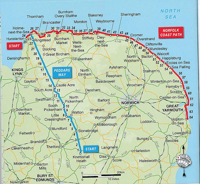
The Norfolk Coast Path & Peddars Way cover 130-miles of walking trails. The Peddars Way runs through East Anglia from Knettishall Heath on the Norfolk/Suffolk border and follows a Roman road to Holme-next-the-Sea. From here it becomes the Norfolk Coast Path, hugging the beautiful Norfolk coastline through Holkham, Wells, Blakeney and Cley to Cromer before it rounds the shoulder of the county and continues along the superb beaches and crumbling cliffs to Mundesley, Sea Palling and Great Yarmouth, finishing just before the Suffolk border.
Includes:
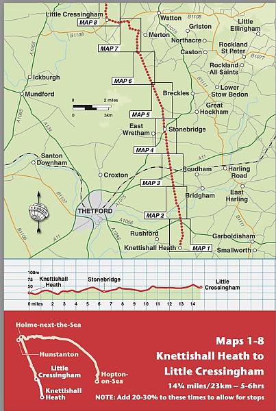
77 large-scale walking maps - at just under 1: 20,000 (8cm or 3 and one eighth inches to 1 mile) our maps are bigger than even the most detailed walking maps currently available, with walking directions, tricky junctions, places to stay and eat, points of interest and walking times written onto the maps
Text and maps in clear TWO-COLOUR style
All standards of accommodation with reviews - campsites, B&Bs, hostels, hotels, bunkhouses
Where to eat with reviews - cafes, teashops, pubs, takeaways and restaurants
Detailed public transport information - for all villages and towns along the paths
Itineraries for all walkers - including one day Peddars Way and Norfolk Coast Path walks, car parks near the trail for weekend and day walkers
Includes 40 mile extension of the National Trail from Cromer to Hopton-on-Sea
Downloadable GPS waypoints with what3words refs
Colour pictures - including a 6 page colour bird and flower guide
Historical, cultural and geographical background information
Engelstalig
EAN: 9781912716395
Auteur(s): Alex stewart
Uitgeverij: Trailblazer
Verschijningsdatum: 2023
Meest recente editie
Engelstalig
244 pagina's


Op voorraad
Overmorgen in huis (Nederland)
- Vakkundige klantenservice
- Groot assortiment
- Gratis retourneren binnen 14 dagen
- Aangesloten bij WebwinkelKEUR
€ 21,50
Meer producten die interessant kunnen zijn
Topografische kaarten Midden-Engeland

Topografische Wandelkaart 196 Sudbury / Hadleigh / Dedham Vale Lavenham & Long Melford - Explorer Map
Wandelkaart & Fietskaart | Ordnance Survey (OS) Groot-Brittannië
€ 18,99

Topografische Wandelkaart 205 Stratford-upon-Avon / Evesham Alcester - Explorer Map
Wandelkaart & Fietskaart | Ordnance Survey (OS) Groot-Brittannië
€ 18,99

Topografische Wandelkaart 211 Bury St Edmunds / Stowmarket Debenham & Elmswell - Explorer Map
Wandelkaart & Fietskaart | Ordnance Survey (OS) Groot-Brittannië
€ 18,99
Tijdelijk niet leverbaar
Topografische Wandelkaart 212 Woodbridge / Saxmundham Aldeburgh & Framlingham - Explorer Map
Wandelkaart & Fietskaart | Ordnance Survey (OS) Groot-Brittannië
€ 18,99
Reisgidsen Midden-Engeland


Reisgids Slow Norfolk Bradt Travel Guide
Local, Characterful Guides To Britain's Special Places
€ 21,50
Wegenkaarten Midden-Engeland

Fietskaarten Midden-Engeland