- Gratis verzending vanaf 30 euro
- Levert in Nederland, België etc.
- Meer dan 30.000 titels
- Vakkundige klantenservice
- Snelle levering
- Veilig en eenvoudig betalen

Direct contact?
Bel +31 (0)6 42428571
maandag t/m vrijdag
van 10 tot 17 uur
Wandelgids Dark Peak Walks | Cicerone Press
40 wandelingen

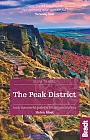
Located in the Peak District and distinguished from the neighbouring White Peak by the layer of gritstone which covers its limestone bed, the Dark Peak features a wild landscape of sweeping moorland and big skies. Easily accessible from Sheffield, it boasts a wealth of natural, geological, historical and cultural interest – and some great walking. This guidebook describes 40 walks in the Dark Peak. Ranging from short strolls to full-day adventures, they showcase the region's unique character. Dramatic waterfalls, striking gritstone edges, heath and woodland are just some of the delights encountered, with many of the routes venturing off-path to explore hidden cloughs and valleys. Detailed route description is provided for 35 walks, accompanied by 1:50,000 OS mapping and interesting facts about local points of interest, then a further five longer walks (of 25-45km) are summarised in the final section, including a classic circuit of the Kinder Scout skyline. Taking in the high moors of Derwent, Bleaklow, Kinder and Howden, the walks reveal not only the area's wild beauty but also some of its fascinating stories. 10,000 years of history lie waiting to be uncovered – from Neolithic burial mounds and Bronze Age cairns to remnants of the region's more recent industrial past. This guide is a perfect companion to discovering the secrets of the Dark Peak and experiencing its magnificent landscape in all its glory.
Engelstalig
EAN: 9781852845193
Uitgeverij: Cicerone Press
Verschijningsdatum: 2017
Meest recente editie
Engelstalig

(Tijdelijk) niet leverbaar
- Vakkundige klantenservice
- Groot assortiment
- Gratis retourneren binnen 14 dagen
- Aangesloten bij WebwinkelKEUR
Meer producten die interessant kunnen zijn
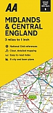
Topografische kaarten Midden-Engeland
Topografische Wandelkaart 196 Sudbury / Hadleigh / Dedham Vale Lavenham & Long Melford - Explorer Map
Wandelkaart & Fietskaart | Ordnance Survey (OS) Groot-Brittannië
€ 18,99
Topografische Wandelkaart 205 Stratford-upon-Avon / Evesham Alcester - Explorer Map
Wandelkaart & Fietskaart | Ordnance Survey (OS) Groot-Brittannië
€ 18,99

Topografische Wandelkaart 211 Bury St Edmunds / Stowmarket Debenham & Elmswell - Explorer Map
Wandelkaart & Fietskaart | Ordnance Survey (OS) Groot-Brittannië
€ 18,99
Tijdelijk niet leverbaar
Topografische Wandelkaart 212 Woodbridge / Saxmundham Aldeburgh & Framlingham - Explorer Map
Wandelkaart & Fietskaart | Ordnance Survey (OS) Groot-Brittannië
€ 18,99
Reisgidsen Midden-Engeland

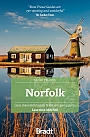
Reisgids Slow Norfolk Bradt Travel Guide
Local, Characterful Guides To Britain's Special Places
€ 21,50
Wegenkaarten Midden-Engeland
Fietskaarten Midden-Engeland