- Gratis verzending vanaf 30 euro
- Levert in Nederland, België etc.
- Meer dan 30.000 titels
- Vakkundige klantenservice
- Snelle levering
- Veilig en eenvoudig betalen

Direct contact?
Bel +31 (0)6 42428571
maandag t/m vrijdag
van 10 tot 17 uur
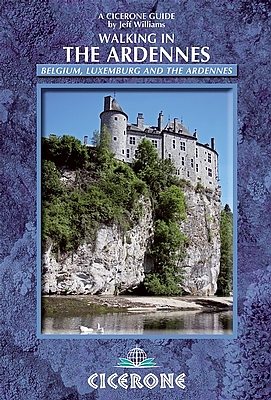
Wandelgids Ardennen Walking in the Ardennes | Cicerone Guide
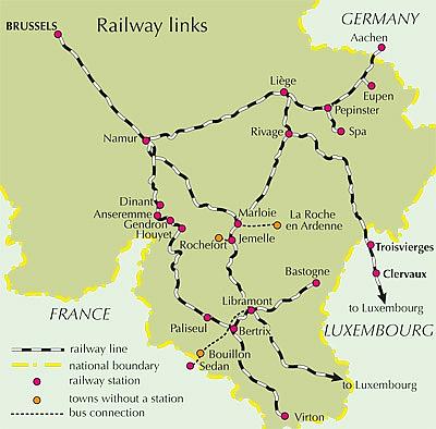
Belgium Luxembourg and the Ardennes
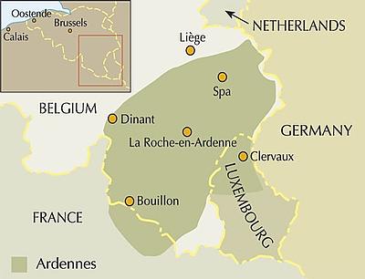
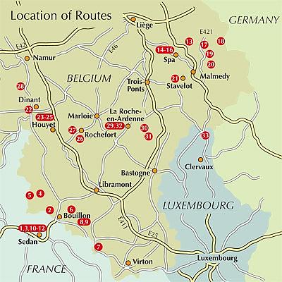
Easily accessible from Calais, the Ardennes region of southeastern Belgium is a great destination for a family walking holiday. This beautiful area of beech and oak-forested hills also offers endless walking opportunities, suitable for a wide range of ages and abilities. Walking in the Ardennes describes 32 day walks based in five centres in Belgium: Bouillon, Spa, Malmedy, Dinant and La Roche-en-Ardenne, and one 68km long-distance route, the Sentier du Nord, divided into six manageable stages that traverse northern Luxembourg from Weiswampach to Diekirch. With numerous outdoor activities, including kayaking and mountain biking as well as the outstanding walking available, the Ardennes is a great destination for a family holiday. Located primarily in south-east Belgium but also stretching over the borders into northern Luxembourg and, to a lesser extent, north-east France, the Ardennes is a beautiful area of beech and oak forests, rolling green hills and deep, winding river valleys. It offers almost endless walking options and is packed with historic sites to visit including medieval castles and fortified farmhouses perched above attractive villages, as well as WWII museums and war relics situated alongside the routes. Military history enthusiasts will be especially enthralled.
The walks described in this guidebook differ in distance and ascent but there are no large height gains and so the walking is all essentially straightforward. There is no difficulty grading system, and no special equipment is required; recommended gear is the same as would be used for countryside walking in the UK. On-road sections have been kept to a minimum. As such, the walking is suitable for a wide range of ages and abilities, and is perfect for all the family. 32 day walks and one 68km route in 6 stages information about the medieval castles, fortified farmhouses and WW2 relics found along the routes practical advice on accommodation, food and drink, when to go and much more Activities
Walking Seasons
walks can be done at any time of year; June and September are best as accommodation is open, crowds are unlikely and there is a good chance of decent weather Centres
Belgium: Dinant, Spa, Bouillon, Malmedy and La Roche-en-Ardenne; Luxembourg: Clervaux Difficulty
walks have no technical difficulties but vary considerably in length and height gain; no specialist equipment is required Must See
the extraordinary and renowned habitat of the Hautes Fagnes; the cave systems at Han-sur-Lesse or Rochefort; Bouillon and its castle; the military museum at Diekirch in Luxembourg
Engelstalig
EAN: 9781852846862
Uitgeverij: Cicerone Press
Verschijningsdatum: 01 jun 2014
Meest recente editie
Engelstalig
Op voorraad
Overmorgen in huis (Nederland)
- Vakkundige klantenservice
- Groot assortiment
- Gratis retourneren binnen 14 dagen
- Aangesloten bij WebwinkelKEUR
€ 22,99
Meer producten die interessant kunnen zijn
Wandelkaarten Ardennen / Wallonië
Topografische kaarten Ardennen / Wallonië
Topografische Wandelkaart België 55/1-2 Durbuy - Erezee Topo25 | NGI België
Wandelkaart | Nationaal Geografisch Instituut (NGI) België
€ 9,90
Topografische Wandelkaart van België 57 Chimay Topo50 | NGI België
Fietskaart en wandelkaart | Nationaal Geografisch Instituut (NGI) België
€ 9,90
Topografische Wandelkaart België 59/3-4 Rochefort - Nassogne Topo25 | NGI België
Wandelkaart | Nationaal Geografisch Instituut (NGI) België
€ 9,90
Topografische Wandelkaart België 60/3-4 Houffalize Topo25 | NGI België
Wandelkaart | Nationaal Geografisch Instituut (NGI) België
€ 9,90
Fietskaarten Ardennen / Wallonië
Fietskaart 2 Wallonië Ardennen België | ADFC Radtourenkarte - BVA Bielefelder Verlag
Water- en scheurvaste fietskaart
€ 11,90
Wegenkaarten Ardennen / Wallonië
Wegenkaart - Landkaart 534 Zuid-België & Ardennen - Michelin Regional
Michelin wegenkaart Vlaanderen Wallonië
€ 11,50
Fietsgidsen Ardennen / Wallonië

Fietsgids Vennbahn-Radweg Bikeline Estherbauer
Von Aachen durch den Naturpark Hohes Venn nach Luxemburg, 1:50.000, 227 km
€ 15,90
Wandelroute GR5 Ardennen / Wallonië
Wandelgids GR 5 Mer du Nord - Mediterranee Wallonie et Luxembourg Traject der Ardennen | Grote Routepaden Topogids
GR5 | Noordzee-Rivièra - Wallonië en GH Luxemburg, Traject der Ardennen | Let Op ! Franstalig
€ 24,99
Tijdelijk niet leverbaar