- Gratis verzending vanaf 30 euro
- Levert in Nederland, België etc.
- Meer dan 30.000 titels
- Vakkundige klantenservice
- Snelle levering
- Veilig en eenvoudig betalen

Direct contact?
Bel +31 (0)6 42428571
maandag t/m vrijdag
van 10 tot 17 uur
Reisgids D-Day Landings | Bradt Travel Guides
A Travel Guide to Normandy's Beaches and Battlegrounds: Sites, Museums, Memorials

Published to commemorate the 80th anniversary of the military mission that changed World War II, D-Day Landings: a Travel Guide to Normandy's Beaches and Battlegrounds is Bradt's new guidebook to visiting beaches, memorials, museums, battlefields and other sites associated with D-Day and the Battle of Normandy (Operation Overlord). A simple-to-follow, portable guide for independent travellers, it includes maps and driving instructions to help visitors go back in time to explore World War II history. Written by two experienced travel writers who, between them, are experts in France and military history, D-Day Landings is designed for visitors who want to see all or part of Normandy. Covering the ground from the D-Day landing beaches (Sword, Juno, Gold, Omaha and Utah) up to the Falaise Gap and Cherbourg, it encompasses both every major site and a host of smaller, less well-known locations - venturing well beyond the coast to include sites associated with the capture of Cherbourg (D+20) and the closing of the Falaise Gap (D+76), which marked the end of the Overlord campaign. Although organised geographically - as befits a travel guide rather than history book - a colour-coded system helps readers understand the historical context by identifying where sites fit into the timeline of the Battle of Normandy and escorting readers through the invasion in a simple, practical format. D-Day Landings aims to enhance the visitor experience by alerting readers to unexpected features such as a 'concrete panzer' pillbox topped by a tank turret around which Utah Beach Museum was constructed. Quirky snippets and human stories colour the text. Learn how Lord Lovat's Commando Piper Bill saw himself as a ballerina or how the Utah Beach landings were accidentally more successful than planned. Children and adults alike will love the 'history-spotter' tick-boxes, such as ten Advanced Landing Ground site plaques to tick off. Meanwhile, extensive information on American forces in Normandy includes not only all major US sites but also tales of intriguing characters involved. Whether you are a military-history enthusiast, have family who fought in Normandy or are simply visiting northern France on holiday, Bradt's D-Day Landings is the guidebook to both plan your trip and take with you.
Engelstalig
EAN: 9781804691700
Uitgeverij: Bradt Travelguides
Verschijningsdatum: 2024
Meest recente editie
Engelstalig
142 pagina's


Op voorraad
Vóór 17 uur besteld, morgen in huis (Nederland)
- Vakkundige klantenservice
- Groot assortiment
- Gratis retourneren binnen 14 dagen
- Aangesloten bij WebwinkelKEUR
€ 13,99
Meer producten die interessant kunnen zijn
Topografische kaarten Normandië

Topografische Wandelkaart van Frankrijk 2008OT - Dieppe / Eu / Forêt d'Arques
Carte de Randonnee | Wandelkaart | Institut Geographique National (IGN) Frankrijk
€ 16,50
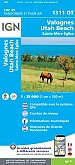
Topografische Wandelkaart van Frankrijk 1311OT Valoges - Ste-Mère-Eglise Utah Beach
Carte de Randonnee | Wandelkaart | Institut Geographique National (IGN) Frankrijk
€ 16,50
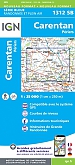
Topografische Wandelkaart van Frankrijk 1312SB - Carentan Périers
Carte de Randonnee | Wandelkaart | Institut Geographique National (IGN) Frankrijk
€ 16,50

Topografische Wandelkaart van Frankrijk 1612OT - Caen / Ouistreham
Carte de Randonnee | Wandelkaart | Institut Geographique National (IGN) Frankrijk
€ 16,50
Wegenkaarten Normandië
Historische kaarten Normandië
Wandelgidsen Normandië
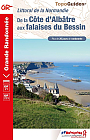
Wandelgids 204 GR223 GR21 De la côte d'Albâtre aux plages du Bessin | FFRP Topoguides
GR 21 GR 223 | Ref. 204
€ 19,90
Wandelgids 200 GR223 Tour du Cotentin | FFRP Topoguides
Plus de 25 jours de randonnée d'Isigny-sur-Mer au Mont Saint-Michel.
€ 18,99
Tijdelijk niet leverbaar
Wandelgids 281 Normandie Rother Wanderführer | Rother Bergverlag
50 Wandelingen | Vom Mont-Saint-Michel bis zur Côte d Albâtre
€ 16,90
Fietsgidsen Normandië
Fietskaarten Normandië
Fietskaart 107 Rouen Le Havre Côte d'Albâtre - IGN Top 100 - Tourisme et Velo
Cote d'Albatre Boucles de la Seine Normande - Water- en scheurvaste fietskaart
€ 10,50

Fietskaart 106 Caen Cherbourg Octeville - IGN Top 100 - Tourisme et Velo
Water- en scheurvaste fietskaart
€ 10,50
Fietskaart 116 Laval Fougeres PNR Normandie Maine - IGN Top 100 - Tourisme et Velo
Water- en scheurvaste fietskaart
€ 10,50
Wandelkaarten Normandië
Wandelkaart Fietskaart 36 Normandie Baie De Somme - Cote d'Albatre Fecamp - Etretat Top 75 | IGN
Institut Géographique National (IGN)
€ 11,99