- Gratis verzending vanaf 30 euro
- Levert in Nederland, België etc.
- Meer dan 30.000 titels
- Vakkundige klantenservice
- Snelle levering
- Veilig en eenvoudig betalen

Direct contact?
Bel +31 (0)6 42428571
maandag t/m vrijdag
van 10 tot 17 uur
Wegenatlas Victoria High Country Atlas & Gids (spiraalverbinding) A4 Formaat - Hema Maps
A4 Formaat met spiraalbinding

Hema Maps, een uitgever uit Australië, maakt fantastische kaarten welke zich kenmerken door het overzichtelijke en rustige karakter. Op de meeste kaarten zijn de dorpen en steden duidelijk aangegeven, inclusief de additionele informatie voor onderweg. Hierbij kun je denken aan een afstandstabel, tankstations, campsites, wegtype, tolwegen, regionale verbindingswegen rondom de steden, spoorwegen en andere belangrijke orientatiepunten. Daarnaast staan op de meeste kaarten ook toeristische bezienswaardigheden aangegeven, zoals natuurparken, natuurfenomen, musea, monumenten, opgravingen enzovoorts. Part 4WD guide, part travel companion, The High Country Atlas & Guide will help you make the most of your time in one of Australia’s most spectacular alpine regions. The guide provides in-depth coverage of the High Country from Mansfield and Wangaratta in the west to Snowy River National Park in the east and from the ski fields at Perisher Valley in the north to Lakes Entrance in the south.
It offers loads of useful information on the area’s rich history, activities and attractions to be enjoyed in all seasons. It also highlights the 25 most outstanding 4WD excursions the High Country has to offer including inset maps, track descriptions, tips, warnings and more. Along with town and supply centre information you can read about the many sights and activities available in Alpine National Park, Snowy River National Park and Baw Baw National Park.
Whether you’re looking for a serious four-wheel drive adventure, a winery tour, a walking trail or a place to stay, this book with its easy-to-follow maps throughout is an indispensable companion.
Features:
– Handy atlas for navigation – from Hema’s best-selling High Country East & West map
– Top 25 4WD Trips, including inset maps, track descriptions, warnings, tips and sites worth exploring along the way
– Detailed maps throughout, including southeast New South Wales
– Towns and localities GPS index
– When to go and how to prepare for the alpine conditions of the High Country
– Where to go for the best outdoor experiences – including bush walking trails, camping and fishing spots
– Where to stay, from B&B's to the best bush-camping sites
– Extensive listings of tour operators – tag-along tours, rental equipment, guided hiking and horse riding, and much more
– Background reading on the region’s geography, history, flora and fauna
Schaal: Diversen
Engelstalig
EAN: 9781876413149
Uitgeverij: Hema Maps Australia
Verschijningsdatum: 2018
Meest recente editie
Engelstalig
160 pagina's


Op voorraad
Levertijd 4 dagen (Nederland)
- Vakkundige klantenservice
- Groot assortiment
- Gratis retourneren binnen 14 dagen
- Aangesloten bij WebwinkelKEUR
€ 46,90
Meer producten die interessant kunnen zijn
Wegenkaarten Australië
Wegenkaart - Landkaart Australië (met Alice Springs, Perth, Sydney en Melbourne) - Nelles Map
Water- en scheurvaste wegenkaart
€ 11,90
Campergidsen Australië
4WD Australië
Wegenatlas Australië Australia Road & 4WD Touring Atlas A4 (spiraalverbinding) - Hema Maps
Formaat 29.7 x 21.5 cm.
€ 38,95
Reisgidsen Australië
Stadsplattegronden Australië
Campinggidsen Australië
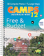
Campinggids Australië Camps Australia Wide 12 with Camp Snaps | Camps Australia Wide
Formaat B4 Met spiraalbinding
€ 99,90