- Gratis verzending vanaf 30 euro
- Levert in Nederland, België etc.
- Meer dan 30.000 titels
- Vakkundige klantenservice
- Snelle levering
- Veilig en eenvoudig betalen

Direct contact?
Bel +31 (0)6 42428571
maandag t/m vrijdag
van 10 tot 17 uur
Wandelkaartgids South West Coast Path Map Booklet - St Ives to Plymouth deel 2 (Zoutpad) | Cicerone
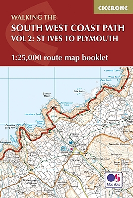
Handzaam kaartgidsje. Gedetailleerde topografische wandelkaarten gebonden in een handig boekje. Licht voor onderweg. Map of part of the southern section of the 630 mile (1014km) South West Coast Path National Trail. Covers the trail from St Ives to Plymouth along the west Cornwall and Devon coastline. This convenient and compact booklet of Ordnance Survey 1:25,000 maps shows the route, providing all of the mapping you need to walk the trail in either direction.
Schaal: 1:25.000
Engelstalig
EAN: 9781852849375
Uitgeverij: Cicerone Press
Serie: National Trail
Verschijningsdatum: 2017
Meest recente editie
Engelstalig

Op voorraad
Levertijd 4 dagen (Nederland)
- Vakkundige klantenservice
- Groot assortiment
- Gratis retourneren binnen 14 dagen
- Aangesloten bij WebwinkelKEUR
€ 17,99
Verder in deze serie

- Wandelgids Ridgeway Cicerone Guidebooks
- Wandelgids South Downs Way described east–west and west–east | Cicerone
- Wandelgids The Cotswolds Way Cicerone Guidebooks
- Wandelgids The Great Glen Way Cicerone Guidebooks
- Wandelgids The Great Glen Way | Cicerone
- Wandelgids The North Downs Way | Cicerone
- Wandelgids The South West Coast Path (Zoutpad) Cicerone Guidebooks
- Wandelgids The Speyside Way Cicerone Guidebooks
- Wandelgids The Thames Path Cicerone Guidebooks
- Wandelgids The West Highland Way Cicerone Guidebooks
- Wandelkaartgids South West Coast Path Map Booklet - Minehead to St Ives deel 1(Zoutpad) | Cicerone
- Wandelkaartgids South West Coast Path Map Booklet - Plymouth to Poole deel 3 (Zoutpad) | Cicerone
- Wandelkaartgids The North Downs Way Booklet | Cicerone
- Wandelkaartgids The Thames Path Map Booklet | Cicerone
- Wandelkaartgids Walking the Cotswold Way | Cicerone
- Wandelkaartgids West Highland Way Map Booklet | Cicerone
Meer producten die interessant kunnen zijn


Topografische Wandelkaart 103 Lizard (the) - Explorer Map
Wandelkaart & Fietskaart | Ordnance Survey (OS) Groot-Brittannië
€ 18,99

Topografische Wandelkaart 106 Newquay / Padstow - Explorer Map
Wandelkaart & Fietskaart | Ordnance Survey (OS) Groot-Brittannië
€ 18,99

Topografische Wandelkaart 107 St-Austell / Liskeard - Explorer Map
Wandelkaart & Fietskaart | Ordnance Survey (OS) Groot-Brittannië
€ 18,99
Tijdelijk niet leverbaar