- Gratis verzending vanaf 30 euro
- Levert in Nederland, België etc.
- Meer dan 30.000 titels
- Vakkundige klantenservice
- Snelle levering
- Veilig en eenvoudig betalen

Direct contact?
Bel +31 (0)6 42428571
maandag t/m vrijdag
van 10 tot 17 uur
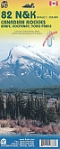
Wegenkaart - Landkaart 3 Alberta Southwest & Southeast British Columbia Driving Map | Gem Trek Publishing

Driving Map of Southwestern Alberta & Southeastern British Columbia (Canada) published by Gem Trek. This 1:500,000-scale map covers Edmonton and Calgary, south to the U.S. border, and west as far as Jasper National Park in the north and Castlegar, in the B.C. Kootenays, in the south. All the major highways are shown, as well as national and provincial parks and wilderness areas. The map also shows lesser-known back roads, and pinpoints the location of lodges, campgrounds and hot springs. Mileage charts provide distances between major towns and cities.
Schaal: 1:500.000
Engelstalig
EAN: 9781895526936
Uitgeverij: Gem Trek Publishing (Canada)
Serie: Gem Trek Wegenkaart
Meest recente editie
Engelstalig


Op voorraad
Overmorgen in huis (Nederland)
- Vakkundige klantenservice
- Groot assortiment
- Gratis retourneren binnen 14 dagen
- Aangesloten bij WebwinkelKEUR
€ 13,90
Verder in deze serie

Meer producten die interessant kunnen zijn
Wandelkaarten British-Columbia
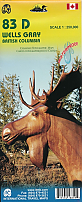
Wandelkaart 83D Wells Gray Park - ITMB Map
Water- en scheurvaste wandelkaart
€ 13,50
Tijdelijk niet leverbaar
Wandelgidsen British-Columbia
Topografische kaarten British-Columbia
Topografische Wandelkaart Canadian Rockies Banff, Kootenay, Yoho Park 82J/K/N/O - ITMB Map
Water- en scheurvaste wandelkaart
€ 13,50
Wildlife-gidsen British-Columbia
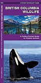
Natuurgids British Columbia Wildlife | Waterford Press
An Introduction to Familiar Species
Tijdelijk niet leverbaar
Reisgidsen British-Columbia